Travel anniversary and a big present

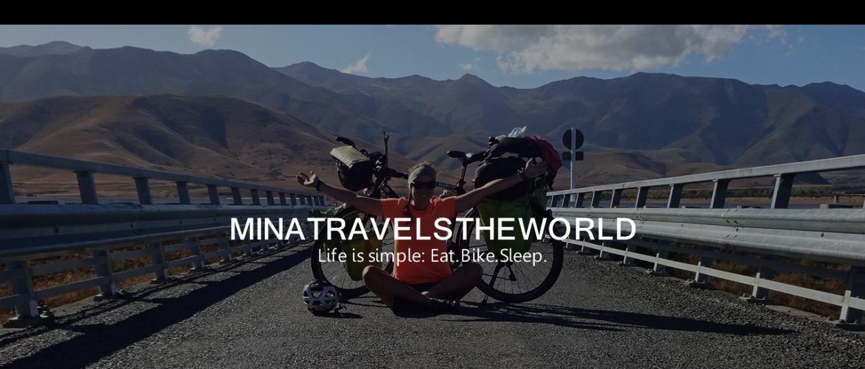
The 11th of January was the big day. Exactly a year ago a good friend of mine gave me (+my bike) a ride to Frankfurt where the adventure was going to begin. Since then, belive it or not, a year has gone by. A year, that I would probably call the best and most exciting year of my life so far. It was the best decision to just go.. biking around the world.. what a brilliant idea I´ve had. I´ve lived my dream the last year and fortunately still have a few month left from now on.
1 year, 13,000 km by bicycle, 8 countries and new “family” and friends all around the world. Thanks to all of you who made my trip as special and unique as it is!!! I am glad that you could be part of my journey.

After Natascha and I had a day off in Wanaka, doing some laundry, etc., we were back on our bikes on Friday, the 13th. What a good date (if you are superstitious) to spontaneously do a skydive from 12,000ft. Before I´ve even started my trip I was planning to do a skydive at some point in New Zealand. Since the weather was simply too bad on the west coast, I hadn´t crossed it off my list as we passed by the small airport in Wanaka this sunny friday. When we got closer to the airport we could already see several parachutes coming down. So I thought, I might just ask if a skydive is possible without a booking or even the same day. And suddenly, about 2.5 hours later, I sat fully equipped in the small airplane and was pretty excited. The skydive was just unbelievable and amazing, a lot of adrenaline, an incredible feeling when you are just freefalling for 45 sec. and a great view. But it definitely was over way too fast. When I was back down, I felt like I could already jump again right away:) I really liked the present, which I´ve made myself;) Maybe I treat myself again to a second skydive one day. I wouldn´t mind another one at all:)

The last days we crossed over Lindis Pass towards Lake Tekapo further north with (of course) a lot, a lot of wind; right..mostly headwinds. We got told that the strong winds which we were fighting these days were not normal for that area. I relieved but for us it surely wasn´t the ideal timing for this “special feature”. Even though I´ve been on the road for a year already I need to change my statement regarding winds one more time. Yesterday I was definitely riding my bike in the strongest winds I´ve ever had since the beginning of my trip. We partly needed to walk the bikes at Tekapo Canal cause it wasn´t possible to ride at all and we didn´t want to give up again like the day before due to wind. Tonight we´ll meet up with my parents who also arrived to NZ a few days ago for their big 4 weeks adventure. We´ll spend some time together and I´m really excited how I like a “family holiday” after such a long time ;).

BILDER–PICTURES: please click here


Am 11.1.2017 war der große Tag. Vor genau einem Jahr hat mich eine gute Freundin zusammen mit meinem Fahrrad nach Frankfurt gebracht, wo das Abenteuer beginnen sollte. Seitdem ist, ob ihr´s glaubt oder nicht, ein Jahr vergangen. Ein Jahr, dass ich wohl bis jetzt als das beste und erlebnisreichste Jahr meines Lebens bezeichnen würde. Es war die beste Entscheidung, einfach loszufahren… mit dem Fahrrad um die Welt, was hatte ich da für eine geniale Idee;) Ich habe das letzte Jahr meinen Traum gelebt und habe dafür zum Glück auch ab jetzt noch ein paar Monate Zeit.
1 Jahr, 13.000 Radkilometer, 8 Länder und neue „Familie“ und Freunde auf der ganzen Welt. Danke an alle, die meine Reise bisher so besonders und einzigartig gemacht haben!!! Ich bin froh, dass ihr Teil meiner Reise ward und seid.

Nachdem Natascha und ich einen Pausentag zum Wäschewaschen etc. in Wanaka eingelegt hatten, sind wir am Freitag, dem 13. weitergefahren. Was gibt es für ein besseres Datum, um spontan aus 12.000ft Höhe aus einem Flugzeug zu springen. Schon vor meiner Abreise hatte ich mir vorgenommen, in Neuseeland einen Fallschirmsprung zu machen. Da an der Westküste einfach viel zu schlechtes Wetter war, stand es immer noch auf meinem Plan, als wir an diesem sonnigen Freitag an dem kleinen Flughafen von Wanaka vorbeigefahren sind. Auf der Fahrt hatten wir schon mehrere Springer beobachtet, also habe ich mir gedacht, ich frage einfach mal nach, wie kurzfristig sowas möglich ist. Und siehe da. Etwa 2,5 Stunden später saß ich in voller Ausrüstung im Flieger und war doch ein bisschen aufgeregt. Der Sprung war einfach geil, Adrenalin hoch 10, ein unglaubliches Gefühl beim Fall und eine super Aussicht. Aber doch ging alles einfach viel zu schnell. Als ich wieder unten war, hätte ich gleich noch mal springen können:) Mein Geschenk, was ich mir gemacht habe, fand ich dennoch ziemlich gut;) Vielleicht gönne ich mir das ja irgendwann noch ein zweites Mal:)

Wir sind die letzten Tage über den Lindis Pass mit viel, viel Wind (richtig!, zu 80% Gegenwind) nach Norden Richtung Lake Tekapo weitergefahren. Der starke Wind, mit dem wir die Tage zu kämpfen hatten, sei wohl nicht normal für die Gegend hier. Darüber bin ich beruhigt, aber für uns war es dennoch nicht gerade optimales Timing für diese “Besonderheit”. Obwohl ich schon ein Jahr unterwegs bin, muss ich mich nun wieder verbessern. Gestern bin ich definitiv in dem stärksten Wind, den ich seit Beginn meiner Reise hatte, gefahren. Wir haben die Räder am Tekapo Canal teilweise geschoben, da es nicht möglich war zu fahren und wir nicht schon wieder, wie am Tag zuvor auf Grund von Wind aufgeben wollten. Heuten Abend treffen wir uns mit unseren Eltern, die vor ein paar Tagen auch zu ihrem vierwöchigen großen Abenteuer nach Neuseeland aufgebrochen sind. Wir werden einige Zeit zusammen verbringen und ich bin sehr gespannt und aufgeregt, wie sich so ein „Familienurlaub“ nach so langer Zeit anfühlt;)

BILDER–PICTURES: please click here

Escaping busy roads

Haast is a perfect and unspectacular place to finally leave the rainy west coast full of joy and excitement. In exceptionally good weather, we headed east towards the Hasst Pass on the  04.1.2017. The pass was a tough one. The first few kilometers of the climb were incredibly steep uphill. It was so steep that for me it was only possible to cycle standing up. Natascha changed her way of transportion after a few difficulties and ended up hitchhiking for a little bit. In the end of the day we had reached the probably most beautiful campingspot in New Zealand – Cameron Flat Campground. Both, the weather, as well as the view were fantastic, only at night I was freezing. In the morning I found out why: When we woke up it was only 1 °C and everything was covered with a slight frost. After the sunrise and some breakfast we carried on towards Wanaka with the most beautiful weather and together with Amy, who we had met at the campsite. The day was definitely unique! Sunshine, breathtakingly beautiful landscapes, along Lake Wanaka and Lake Hawea with snow-capped mountains in the background and just soooo many photo stops. In the village Lake Hawea we bought a 2 liter pack of ice cream and finished it all. It was a really summery and warm day and 2 liter of ice cream with 3 people is absolutely not a big deal;)

After an overnight stop in Alberts Town we rode to Wanaka the next morning and the place was just crowded with tourists. I won´t try to guess how many times the population increases in Wanaka during the season. There are several cafes, shops and restaurants located in the town center, all very busy regardless of the prices. The road, which runs along the waterfront through town is busy with traffic the whole time and the only supermarket in town probably makes the best daily turnover of the year every day.

When we found out that we could leave the bikes at the campsite, where we had planned to stay, we decided to spontaneously leave for a longer hike the next day. It´s right, that we are pretty much out in nature and the fresh air the whole time, 24 hours a day. But there is also a lot of traffic with us on the roads. You always need to be really concentrated and pay attention to the cars, road conditions, dangerous overtaking maneuvers or the wind gusts. To escape all that and also all the tourists, we hitchhiked to Glendhu Bay on the 7th of January. That´s where we startet to hike the Motapatu Track, which is part of the Te Araroa (the trail which crosses both islands from the northern tip to the southern tip ). The Motapatu Track has a total distance of 34 km and ends in Arrowtown. In between are multiple basic huts where you can stay overnight or you could also camp. It felt so incredibly good to be off the beaten track. It was so quiet in the mountains, you could only hear the birds, the wind and the streams and within the 5 days of hiking we hadn´t met more than maybe 20 other hikers. The track, if in parts you can even call it a track at all, was quite a challenge. It went steadily steeply uphill and downhill and with steep I mean very steep. Despite some sore muscles, which I surprisingly already had after the first day, the scenic was beautiful and special and the weather just awesome. We really enjoyed our short trip into the moutains.
Yesterday we arrived in Arrowtown and headed back to our bicycles in Wanaka. We havn´t decided yet where we go from here… My parents will be in NZ soon as well :)

PICTURES–BILDER: please click here


Haast ist ein perfektes unspektakuläres Örtchen, um froh und erwartungsvoll die regnerische Westküste zu verlassen. Bei ausnahmsweise gutem Wetter sind wir am 04.1.2017 Richtung Haast Pass nach Osten aufgebrochen. Der Pass hatte es in sich. Auf den ersten paar Kilometern ging es unglaublich steil bergauf. Es war so steil, dass es für mich nur möglich war durchgehend im Stehen zu fahren und Natascha nach einigen Schwierigkeiten das Transportmittel gewechselt hat und ein Stück getrampt ist. Der Tag endete an dem wohl bislang schönstem Campingspot in Neuseeland- Cameron Flat Campground. Sowohl das Wetter, als auch die Aussicht waren traumhaft, nur in der Nacht war mir etwas kalt. Morgens wusste ich wieso: Wir sind bei gerade mal 1°C aufgewacht und alles war mit leichtem Frost überzogen. Nach dem Sonnenaufgang und dem Frühstück sind wir bei strahlend blauem Himmel weiter nach Wanaka gefahren; zusammen mit Amy, die wir am Campingplatz kennengelernt hatten. Der Tag war einzigartig! Sonnenschein, atemberaubend schöne Landschaften, entlang von Lake Wanaka und Lake Hawea mit schneebedeckten Bergen im Hintergrund und einfach unendlich vielen Foto Stopps. Im Ort Lake Hawea angekommen musste erstmal eine 2 Liter Packung Eis dran glauben. Schließlich war es ausnahmsweise mal ein richtig sommerlicher Tag und mit 3 Leuten sind 2 Liter ja absolut kein Thema;)

Nach einem Übernachtungsstopp in Albert Town sind wir den nächsten Morgen das letzte Stück nach Wanaka gefahren und wurden regelrecht erschlagen von den Toursitenmassen, die sich in dem Ort befinden. Ich verkneife mir mal die Schätzung auf das wie vielfache die Bevölkerung hier dem Ort in der Saison ansteigt. Die kleine Innenstadt besteht aus etlichen Cafés, Shops und Restaurants, die alle unabhängig von den Preisen sehr gut besucht sind. Auf der Straße, die am Wasser entlang durch den Ort geht ist ein Dauerstau und der einzige Supermarkt im Ort macht wohl täglich den Umsatz des Jahres.

Als wir herausgefunden hatten, dass wir die Räder an dem Campingplatz lassen können, wo wir geplant hatten zu übernachten, sind wir am kommenden Tag ganz spontan zu einer Wanderung aufgebrochen. Es stimmt wohl, dass wir uns täglich eigentlich 24 Stunden in der Natur befinden und uns die frische Luft um die Nase weht. Aber es ist auch immer der viele Verkehr mit uns auf den Straßen unterwegs. Man muss ständig sehr konzentriert sein und auf Autos, die Straßenbeschaffenheit, gefährliche Überholmanöver oder Windböen achten. Um dem Ganzen und auch den Touristenmassen zu entfliehen sind wir also am 7.1.2017 nach Glendhu Bay getramt und sind von dort aus zum Motapatu Track gelaufen, der Teil des Te Araroa ist ( der Wanderweg, der über beide Inseln von der Nordspitze zur Südspitze geht). Der Motapatu Track ist insgesamt 34 km lang und endet in Arrowtown, wobei man durchgehend in der Natur ist. Zwischendurch sind unbewirtschaftete Hütten, in denen man übernachten kann oder man zeltet. Es tat unglaublich gut mal wieder abseits der Massen zu sein. Es war eine Stille in den Bergen, man hat nur die Vögel, den Wind und die Bäche gehört und insgesamt haben wir in den 5 Tagen nicht mehr als vielleicht 20 anderer Wanderer getroffen. Der Track, wenn man in Teilen überhaupt von einem Track sprechen kann, war schon eine kleine Herausforderung. Es ging durchgehend steil bergauf und bergab und mit steil meine ich sehr steil. Trotz Muskelkater, der sich schon nach dem ersten Tag bemerkbar machte, war es landschaftlich super schön und speziell. Zudem hatten wir ziemliches Glück mit dem Wetter.
Gestern sind wir in Arrowtown angekommen und wieder zurück nach Wanaka zu unseren Fahrrädern getrampt. Nun gucken wir mal, wie es von hier aus weiter geht. Bald kommen ja auch schon meine Eltern:)

PICTURES–BILDER: please click here

The WET Coast of NZ

I don´t know why people think the westcoast of the south island of NZ is so beautiful. In my opinion in most parts the scenery is not really attractiv. There is a small but pretty section north of Greymouth, where the road is right beside the ocean. In total I have to say that we were not really lucky with the weather. Even though the sun did shine, the moutains somewhere east of the highway were always covered by clouds. The coast is still advertised too good. One of the touristic highlights on the coast are the Pancake Rocks. You can park the car on the highway right beside the souvenir shop, a café and an information center to walk the 20-minute round track. Along the track you get to see the special rock formations from different viewpoints where you can also take some pictures. Of course we went as well and could check it off our list.
During our time on the west coast christmas was almost there. Here in NZ the important day during christmas is the December, the 25th. It´s the only day all year around where everything is closed, even fast food chains and most of the restaurants. Only one gas station was open. After spending two days in Greymouth with our warmshower host, we carried on going southwards. We took the Wilderness Trail and it was quite enjoyable to avoid the busy roads and we could even see some of the mountains for the first time.
Along the West Coast between Greymouth and Haast it´s said that the population is about 1000 people. Our guess is that the population certainly rises about 10 times in the season. At least it feels like it does. It´s kind of a pity cause all the special and scenic places on the West coast, like the Pancake Rocks, Franz Josef Glacier or Fox Glacier are just crowded with tourists. They are like ans, walking from the carpark along a narrow hiking trail to take their picture of or in front of the glacier. Between all the colorful ans we´ve also seen groups of 20 blue ants, all wearing the same raincoats, black rain pants and black boots. All these people probably belong to one of the guided tours which go up to the glacier or perhaps even up on the ice. I guess the equipment is provided because some people would show up in Flip-Flops and dresses, which is not really suitable for the weather conditions on the West Coast. ..Not even for just a short walk.

I know it sounds weird when I always talk about ´tourists´ even thought I´m 100% a tourist myself. But I would rather talk about me as a traveler, a world traveler or an adventurous cyclist.. if you know what I mean.;)
While cycling on the road along the coast, we noticed that about 60 % of the cars are motor homes, caravans or any other rented cars. Most of them of course were driving risky and didn´t care about cyclists. NZ definitely seems to be a really popular and famous travel destination and not everyone can be as crazy as we are travelling by bicycle;)

The towns Franz Josef and Fox Glacier are pretty much just an area with hotels, camping grounds, motor parks, hostels, souvenir shops and informationcenter for helicopter flights. We were glad thought that we at least found a hostel with vacancy and we could spontaneously check in for New Year´s eve. It wasn´t even noon yet but it had started to rain or I should better say to pour, so we were glad to have a dry place to stay. It rained non-stop for 16 hours but exceptionally it couldn´t bother us. We spend the evening with a few other traveler, sitting together, having some beer and wine and welcomed the new year quite unspectaculary. Happy New Year!!!
In Fox Glacier we were lucky and could camp just outside the town beside a shed. The next morning we found out that the helicopters of about 3 different companies start flying at 7 o´clock. They are doing roundtrips close to the glacier and it comes along with a continuous noise cause you would find 2-3 helicopter at a time up in the air. I felt sorry for the people who had booked their glacier flight maybe weeks in advance and then they needed to enjoy it even thought the mountains were covered in clouds and you could hardly see anything.
Two days later we arrived in Haast, our last stop at the WET Coast.

PICTURES–BILDER: please click here


Ich weiß nicht, was die Leute an der ach so schönen Westküste der Südinsel Neuseelands finden. Sie ist landschaftlich meiner Meinung nach nicht wirklich reizvoll, nur in einem ganz kleinen Abschnitt nördlich von Greymouth, wo die Straße direkt am Wasser entlang geht. Man muss dazu sagen, dass wir ziemliches Pech mit dem Wetter hatten. Das heißt, auch wenn die Sonne geschienen hat, waren die Berge, die irgendwo östlich der Küstenstraße liegen sollten, immer durch eine Wolkenschicht verdeckt. Vermarktet wird die Küste dennoch viel zu gut. Eines der touristischen Highlights an der Küste sind die Pancake Rocks. Man kann an der Hauptstraße bei Souvenirladen, Café und Infocenter parken und den etwa 20- minütigen Rundweg laufen. Von dem Weg aus kann man die besonderen Steinformationen von verschiedenen Punkten aus betrachten und sein Foto machen kann. Natürlich haben wir das auch abgehakt.

Irgendwann an der Westküste stand auf einmal Weihnachten vor der Tür, was für uns aber ein ganz normaler Tag war. Hier in Neuseeland ist der 25.12. der wichtigste Tag über die Weihnachtzeit. Es ist der einzige Tag im ganzen Jahr, wo alles geschlossen ist, sogar Fast Food Ketten und die meisten Restaurants. Nur eine Tankstelle war offen. Nachdem wir in Greymouth bei unserem Warmshowerhost zwei Pausentage eingelegt hatten, ging es am 28.12.2017 auf dem Wilderness Trail weiter Richtung Süden. Der Trail war eine willkommene Abwechslung zu den viel befahrenen Straßen und wir konnten sogar einen Teil der Berge das erste Mal sehen.
Entlang der Westküste zwischen Greymouth und Haast soll die Bevölkerungsanzahl etwa 1000 Menschen betragen. Wir haben Schätzung angestellt, dass die Bevölkerung in der Saison sicherlich auf etwa das 10-fache ansteigt. Zumindest fühlt es sich so an. Es ist irgendwie schade, denn die einzigen besonderen oder sehenswerten Orte an der Westküste, wie beispielsweise die Pancake Rocks, der Franz Josef Glacier oder der Fox Glacier sind überfüllt mit Touristen. Wie Ameisen laufen sie beim Gletscher von dem Car Park einen schmalen Wanderweg entlang, um ihr Foto von/vor dem Gletscher zu machen. Zwischen den ganzen bunten Ameisen haben wir auch Gruppen von 20 blauen Ameisen gesehen, die alle die selben Regenjacken, schwarze Regenhosen und schwarze Boots tragen. Dabei handelt es sind dann um die geführten Ausflugsgruppen, die bis zur Gletscherzunge gehen oder vielleicht auch bis aufs Eis. Wahrscheinlich wird die Ausrüstung zur Verfügung gestellt, weil einige Leute sonst in Flipflops und Kleidchen dort auftauchen würden, was für die Wetterbedingungen an der Westküste und auch für eine nur kurze Wanderung nicht gerade die perfekte Kleidung ist.

Ich weiß, es hört sich etwas blöd an, wenn ich über ´die Touristen´ schreibe, wenn ich doch selbst eigentlich ein Tourist in den ganzen Ländern bin. Ich würde mich aber eher und lieber als Reisende, als Weltenbummlerin oder abenteuerlustige Radreisende bezeichnen, wenn ihr versteht, was ich meine:)

Als wir so auf der Straße an der Küste unterwegs waren, haben wir festgestellt, dass etwa 60 % der Autos, wovon viele einen wie immer viel zu dicht, respektlos und risikoreich überholen oder entgegenkommen, Wohnmobile, Karawane oder andere gemietete Autos sind. Neuseeland scheint halt wirklich ein berühmtes/ beliebtes Urlaubsziel zu sein und es kann ja nicht jeder so verrückt sein und mit dem Fahrrad fahren;)

Die Örtchen Franz Josef Glacier und Fox Glacier bestehen gefühlt nur aus Hotels, Campingplätzen, Motor Parks, Hostels, Souvenirläden, und Infocenter über Helikopterflüge. Wir waren ganz froh darüber, dass wenigstens ein Hostel in Franz Josef noch nicht ausgebucht war und wir Silvester ganz spontan einchecken konnten. Es war zwar noch nicht mal Mittag, aber es hatte angefangen zu regnen oder viel mehr zu schütten, sodass wir froh waren im Trockenen zu sein. 16 Stunden hat es durchgeregnet aber das konnte uns ausnahmsweise mal nicht stören. Abends saßen wir mit ein paar anderen Reisenden zusammen und haben mit ein paar Bierchen und Wein ganz unspektakulär das neue Jahr begrüßt. Frohes Neues!:)
In Fox Glacier konnten wir den nächsten Tag etwas außerhalb des Ortes bei einem Schuppen zelten. Dort durften wir feststellen, dass um 7 Uhr morgens die Helikopter von etwa 3 verschiedenen Gesellschaften mit ihre Rundflüge starten. Es ist mit durchgehendem Lärm verbunden, da sich sicherlich immer 2-3 Helikopter gleichzeitig in der Luft befinden. Ich habe die Leute ein bisschen bedauert, die ihren Flug bestimmt weit im Voraus gebucht hatten und nun bei diesem schlechten bewölkten Wetter ihren Rundflug Richtung Gletscher genießen mussten. Zwei Tage später waren wir in Haast angekommen, unser letzter Stopp an der WET Coast.

PICTURES–BILDER: please click here

It´s all downhill to Westport

Leaving Able Tasman National Park we first needed to go south to get to the west coast. In the pictures, it looks like the weather is perfect but it´s looks better than is was. We often had strong headwinds together with the well-known ruthless car / truck drivers so that I was glad to be off the road quite a few times in the evening. The scenery didn´t change a lot. We mainly rode through  farmland, but in the distance you could already see some higher mountains of the South Island. From Murchison we took Hwy 6 through the ‘Buller Gorge’ to Westport. On the way we found an interesting place to stay. We asked at a house along the way, if we could camp on the property for a night. It turned out that the house is owned by an old man, who had lived there for decades and had bought a whole section of the valley when he was very young. He lives totally independent, builds everything himself, uses the spring water near the house, heats and cooks with fire, uses electricity from a few solar panels, has a huge garden, chickens, a cow, makes his own cheese, has horses and an old stagecoach. It was an interesting evening and we were happy to have met him and that we got to know his way of life.
When we carried on the next day, we had to find out again that you shouldn´t always belive in what other people tell you. The statement that you go through the ‘Buller Gorge’ when you cycle from Murchison to Westport and that it´s actually all downhill along the river is not quite right. Contrary it went up and down the whole time. Additional, we had super strong west wind, which even felt worse and gathered in the gorge and didn´t really help us cycling that day. Late in the evening we arrived at the campground in Westport after a long day of biking. Hello West Coast!
The coast welcomed us with plenty of rain over night. This way pools were included in the price for the campside cause the grass where our tent were pitched couldn´t absorb the water any more. We were happy to have planned a day off, as the next day the heavy rain didn´t stop until the afternoon.
The people who had told us about a lot of rain on the west coast might have been right. Well, hope dies last!

PICTURES–BILDER:  please click here


Um von dem Able Tasman National Park zur Westküste zu kommen, mussten wir erstmal ein Stück Richtung Süden fahren. Auf den Fotos sieht es nach top Wetter aus, doch der Schein trügt. Wir hatten oft mit ziemlichem Gegenwind zu kämpfen und zusammen mit den bekannten rücksichtslosen Auto-/LKW Fahrern war ich einige Male genervt und froh abends endlich von der Straße runter zu sein. Landschaftlich war es weiterhin überwiegend Farmland, doch in der Ferne sah man nun schon endlich die höheren Berge der Südinsel. Von Murchison aus sind wir durch die ´Buller Gorge´ nach Westport gefahren, wobei wir einen interessanten Übernachtungsort gefunden hatten. Wir haben an einem Haus an der Straße angefragt, ob wir dort zelten/übernachten könnten. Es stellte sich heraus, dass das Haus einem alten Herren gehört, der schon Jahrzehnte dort lebt und sehr jung einen ganzen Abschnitt des Tals gekauft hatte. Er lebt total unabhängig, baut alles selbst, nutzt das Quellwasser in der Nähe des Hauses, heizt und kocht mit Feuer, nutzt die Elektrizität von ein paar Solarzellen, hat einen riesigen Garten, Hühner, eine Kuh, macht seinen eigenen Käse, hat Pferde und eine alte Postkutsche. Es war ein interessanter Abend und wir waren froh ihn und seine Lebensweise kennen lernen zu dürfen.

Als wir am nächsten Tag weitergefahren sind, mussten wir mal wieder feststellen, dass man sich nicht immer auf die Aussage anderer Leute verlassen sollte. Entgegen der Aussagen, dass es durch in der ´Buller Gorge´ eigentlich durchgehend bergab am Fluss entlang bis nach Westport geht, ging es immer wieder auf und ab. Hinzu kam, dass wir den Tag sehr starken Westwind hatten. Durch die Schlucht hat er sich gefühlt noch gesammelt und uns das Fahren nicht gerade erleichtert. Wir sind spät abends nach einem langen Tag auf dem Campingplatz in Westport angekommen. Hallo Westküste!
Begrüßt wurden wir in der Nacht auch gleich mit sehr viel Regen. Pools waren somit auf dem Campingplatz inklusive, denn die Wiese auf der die Zelte standen, konnte das Wasser schon gar nicht mehr aufnehmen. Wir waren froh einen Pausentag geplant zu haben, als es den nächsten Tag bis in den Nachmittag hinein noch weiter im Strömen regnete.
Die Leute, die uns von dem vielen Regen an der Westküste erzählt hatten, hatten vielleicht doch nicht ganz Unrecht?! Nun ja, die Hoffnung stirbt zuletzt!

PICTURES–BILDER:  please click here