Category Archives: WORLD 2016/2017

Diary posts from my World trip 2016/2017

Cheating on my way back to Wellington

My parents had dropped me off in Queenstown from where I travelled on again by bike. I cycled from Queenstown through the Kawarau Gorge to Cromwell and from there through the Cromwell Gorge to Clyde. Although the routes were quite scenic, the roads through the gorges felt tight. After two weeks in the campervan I had to once again get used to all the crazy car drivers;)
The ‘Otago Central Rail Trail’, which I had been looking forward to, started in Clyde. The trail runs 150km along an old railway track, which has been converted into a cycle track. It leads through beautiful landscapes and has, exceptionally, no single steep ascent. Yey! ;) It was very windy but a lot of sunshine made the two days enjoyable nevertheless. A day later, I was back in Dunedin, where I had been only two weeks earlier. From Dunedin it felt much felt as hitchhikers continued. There were parts that I did not necessarily want to ride by bike, as I had seen them from the campervan –  the roads were not very scenic or where they were scenic they weree very busy. After a day hitchhiking and two days cycling I arrived in Darfield near Christchurch.
I travelled in to Christchurch to meet my parents on their last day before they flew back to Germany for her Sunday. Christchurch is still very much affected by the earthquake. Many houses are empty because they are no longer allowed to be entered due to safety concerns. There are many construction sites and empty spaces between houses where now destroyed houses once stood. I have only seen a small a part of Christchurch so I can not give you a really detailed picture. There is definitely a nice park, where I had a picnic with my parents and enjoyed the sun.
From Darfield, I hitched a ride through the Arthur’s Pass back to the WET Coast. I had really wanted to do ride the pass by bike, but bad weather and strong winds put a stop to that. intersected by the north again, to Picton from where I caught the ferry back to Wellington. It was now faster than thought, but somehow it was also slow time to come back to the North Island. I would had liked to have enough weeks here to take some bike trails / ‘backroads’ and walk between them. Once again I got some good travel tips from my host Stuart for the journey north. I will take the train from Wellington to Palmerston North tomorrow and continue from there up the North Island.

BILDER–PICTURES:please click here


Nachdem mich meine Eltern abgesetzt hatten, ging es wieder auf dem Fahrrad weiter. Ich bin von Queenstown durch die Kawarau Gorge nach Cromwell und von dort durch die Cromwell Gorge nach Clyde gefahren. Die Strecken waren zwar landschaftlich ziemlich schön, aber die Straße hat sie durch die Schluchten (Gorge) irgendwie noch enger angefühlt. Wahrscheinlich musste ich mich nach zwei Wochen im Camper Van auch erstmal wieder ein bisschen an die ganzen verrückten Autofahrer gewöhnen;) In Clyde angekommen ging es auf dem  ´Otago Central Rail Trail´ weiter, worauf ich mich schon gefreut hatte. Es lagen nämlich 150km auf einer alten, zu einem Radweg umgebauten Bahnstrecke vor mir. Der Trail führt durch wunderschöne Landschaften und hat ausnahmsweise keinen einzigen steilen Anstieg. Yeai;) Es war zwar windig aber mit viel Sonnenschein habe ich die zwei Tage dennoch genossen. Einen Tag später war ich dann auch schon wieder in Dunedin, wo ich ja vor etwa zwei Wochen erst war.  Ab Dunedin ging es gefühlt größtenteil als Anhalter weiter. Es gab Teile, die ich nicht unbedingt mit dem Fahrrad fahren wollte, da ich sie entweder schon vom Camper Van aus gesehen hatte, sie landschaftlich nicht wirklich reizvoll waren oder es sehr viel befahrene Straßen waren.
Nach einem Tag Trampen und zwei Tagen radeln war ich in Darfield in der Nähe von Christchurch angekommen. In Christchurch habe ich mich am nächsten Tag noch ein letztes Mal mit meinen Eltern getroffen, bevor es für sie Sonntag zurück nach Deutschland ging.
Christchurch ist noch sehr geprägt von dem Erdbeben. Viele Häuser sind leer, weil sie nicht mehr betreten werden dürfen, es gibt viele Baustellen und immer wieder leere Schotterflächen zwischen den Häusern, wo einst einmal ein Haus gestanden hat. Ich habe allerdins nur einen so geringen Teil von Christchurch gesehen, dass ich euch kein wirklich detailiertes Bild geben kann. Es gibt auf jeden Fall einen schönen Park, wo ich mit meinem Eltern ein Picknick gemacht und die Sonne genossen habe.

Von Darfield bin ich LEIDER auf Grund von Wetter und starken Winden über den Arthur´s Pass getramt (was ich eigentlich so sehr mit dem Rad machen wollte) , zurück zur WET Coast, zwischendurch mal wieder geradelt, Richtung Norden, bis nach Picton und gestern mit der Fähre zurück nach Wellington. Es ging nun doch schneller als gedachte, aber irgendwie war es auch langsam Zeit wieder zurück zur Nordinsel zu kommen. Ich möchte hier noch genug Wochen haben, um einige Radwege/ ´back roads´ zu nehmen und zwischendurch wandern zu gehen. Mit wieder einigen guten Tipps von meinem host Stuart in der Tasche, nehme ich nachher den Zug aus Wellington raus und morgen geht es hier auf der Nordinsel weiter.

BILDER–PICTURES:please click here

Two weeks, one family and a campervan

It is hard to get two weeks so packed with experiences, situations, emotions, places and activities to fit into a single blog entry. I will try to give you a rough summary, upload a lot of pictures and exceptionally keep everything else to myself.
I can tell you that a family holiday can be quite exhausting after spending a year alone in the world. We had some disagreements and it took a little time until everything worked out. Finally, four opinions or views met. But I don´t want to talk too negatively, because we had an incredible time together and it was overall very nice to be able to have a small family holiday as part of my world trip. I enjoyed the time alone with my sister beforehand, as well as the time with the whole family. We had many walks together, saw lots of viewpoints and pretty places and camped in some super beautiful and remote places. The weather was not always on our side. Even though the pictures look sunny again, we had a few days and nights when it did not stop raining. During these rainy evenings we sat comfortably in the campervan, playing cards or planning the next days’ events. During the day, when it rained once again, I appreciated the comforts and dryness of a motorized vehicle.
After Natascha and I had met with my parents near Twizel, our luggage was stowed in the interior of the campervan and the bicycles were strapped onto a very unstable bicycle carrier. Let’s go … New Zealand in a campervan.
Our route was: Twizel to Mount Cook, to Oamaru on the east coast, along the coast to the south, past Dunedin, along the Catlins Coast to Invercargill. From there, on the Scenic Route, we headed for Te Anau and Milford Sound. At Milford Sound, my mother finally managed to redeem her birthday present, which she had received last year in May from my sister and me for her 50th – a boat trip in Milford Sound. Luckily the weather played along and it was a breathtaking and long day, with a boat trip, wildlife we´ve seen just 2m away from us, a 6 hour hike, late dinner, a container of ice cream and a cool beer :) Returning from Milford Sound, we said goodbye to Natascha the next day, who wanted to travel alone from there on. My parents and I went on together to Queenstown. After a trip up to Glenorchy and the Routeburn Track, a few hikes and a jump into the cold lake, I said goodbye to my parents on February 1st. They are still exploring the area, which I had already seen by bike, for 10 days, and then fly back to Germany. How fast the time has passed. Since Queenstown I’ve also been traveling alone with my bike again and have ridden east (again). I plan to reach the North Island in the next few weeks, to return to Auckland by riding up the West Coast. I´m glad I still have a few weeks left until I take the plane to Australia.

PICTURES- BILDER:

Mt Cook, Mueller hut, Clay cliffs: please click here

The east coast down from Oamaru, Catlins: please click here

Milford Sound, hiking, Queenstown: please click here


Es ist schwer, zwei Wochen, die so vollgepackt waren mit Erlebnissen, Situationen, Emotionen, Orten und Unternehmungen in einem Blogeintrag unterzukriegen. Ich werde euch versuchen eine grobe Zusammenfassung zu geben, aber das meiste einfach mit Bildern wiedergeben oder ausnahmsweise mal für mich behalten:)

Ich kann euch sagen, dass ein Familienurlaub ganz schön anstrengend sein kann, nachdem man sich ein Jahr lang so alleine in der Weltgeschichte rumgetrieben hat. Es dauerte ein wenig bis sich alles eingespielt hatte und es gab zwischendurch immer mal die eine oder andere Zickerei. Schließlich trafen auf einmal vier Meinungen oder Ansichten aufeinander. Aber ich will nicht zu schlecht reden, denn wir hatten eine unglaubliche Zeit zusammen und es war insgesamt sehr schön einen kleinen Familienurlaub in meine Weltreise einbauen zu können. Ich habe sowohl die Zeit vorher alleine mit meiner Schwester genossen, als auch die Zeit mit der ganzen Familie. Wir haben viele Wanderungen zusammen gemacht, Viewpoints und touristische Punkte abgeklappert und an einigen super schönen und auch abgelegenen Plätzen gecampt. Das Wetter war leider nicht immer ganz auf unserer Seite. Auch wenn es auf den Fotos wieder meistens sonnig aussieht, hatten wir einige viele Tage und Nächte, in denen es einfach nicht aufhören wollte zu regnen oder zu stürmen. Diese regnerischen Abende haben wir dann gemütlich im Camper Van gesessen, Karten gespielt oder die nächsten Tage geplant. Tagsüber, wenn es mal wieder in Strömen regnete, wusste man es dann erst recht zu schätzen mit einem motorisierten Fahrzeug unterwegs zu sein.

Nachdem Natascha und ich uns in der Nähe von Twizel mit meinen Eltern getroffen hatten, wurde Nataschas und mein ganzes Gepäck im Innenraum des Camper Vans verstaut und die Fahrräder auf einen sehr unstabil wirkenden Fahrradträger geschnallt. Los geht´s.. Neuseeland im Camper Van.
Unsere Route war: zum Mount Cook, von dort Richtung Oamaru zur Ostküste, an der Küste nach Süden, an Dunedin vorbei, an der Catlins Coast entlang durch Invercargill. Von dort aus ging es auf der Scenic Route weiter nach Te Anau und zum Milford Sound. Im Milford Sound konnte meine Ma endlich ihr Geburtstagsgeschenk einlösen, was sie letztes Jahr im Mai von meiner Schwester und mir zu ihrem 50. bekommen hatte- eine Bootstour im Milford Sound. Ausnahmsweise und zum Glück hat das Wetter mitgespielt und es war ein atemberaubender und langer Tag, mit Bootstour, Wildlife 2m entfernt von uns, einer 6-stündigen Wanderung, spätem Abendessen, einer Packung Eis und einem kühlen Bier:)  Wieder aus dem Milford Sound zurück, haben wir uns von Natascha verabschiedet, die von dort aus alleine weiterziehen wollte. Meine Eltern und ich sind noch zusammen weiter nach Queenstown gefahren. Nach einem Abstecher hoch nach Glenorchy und bis zum Routeburn Track, ein paar Wanderungen und einem Sprung in den kalten See, hieß es am 1. Februar auch für mich Abschied nehmen. Meine Eltern erkunden noch 10 Tage genau die Gegend, die ich schon per Rad bereist hatte und fliegen dann auch schon wieder zurück nach Deutschland. Wie schnell die Zeit doch vergangen ist. Ich bin seit Queenstown also auch wieder alleine mit meinem Rad unterwegs und bin (wieder) Richtung Osten gefahren. Ich plane in den nächsten Wochen die Nordinsel zu erreichen, um dort an der Westküste zurück nach Auckland zu fahren. Ein bisschen Zeit habe ich ja schließlich noch bevor ich meinen Flieger nach Australien nehme.

PICTURES- BILDER:

Mt Cook, Mueller hut, Clay cliffs: please click here

The east coast down from Oamaru, Catlins: please click here

Milford Sound, hiking, Queenstown: please click here

Travel anniversary and a big present

The 11th of January was the big day. Exactly a year ago a good friend of mine gave me (+my bike) a ride to Frankfurt where the adventure was going to begin. Since then, belive it or not, a year has gone by. A year, that I would probably call the best and most exciting year of my life so far. It was the best decision to just go.. biking around the world.. what a brilliant idea I´ve had. I´ve lived my dream the last year and fortunately still have a few month left from now on.
1 year, 13,000 km by bicycle, 8 countries and new “family” and friends all around the world. Thanks to all of you who made my trip as special and unique as it is!!! I am glad that you could be part of my journey.

After Natascha and I had a day off in Wanaka, doing some laundry, etc., we were back on our bikes on Friday, the 13th. What a good date (if you are superstitious) to spontaneously do a skydive from 12,000ft. Before I´ve even started my trip I was planning to do a skydive at some point in New Zealand. Since the weather was simply too bad on the west coast, I hadn´t crossed it off my list as we passed by the small airport in Wanaka this sunny friday. When we got closer to the airport we could already see several parachutes coming down. So I thought, I might just ask if a skydive is possible without a booking or even the same day. And suddenly, about 2.5 hours later, I sat fully equipped in the small airplane and was pretty excited. The skydive was just unbelievable and amazing, a lot of adrenaline, an incredible feeling when you are just freefalling for 45 sec. and a great view. But it definitely was over way too fast. When I was back down, I felt like I could already jump again right away:) I really liked the present, which I´ve made myself;) Maybe I treat myself again to a second skydive one day. I wouldn´t mind another one at all:)

The last days we crossed over Lindis Pass towards Lake Tekapo further north with (of course) a lot, a lot of wind; right..mostly headwinds. We got told that the strong winds which we were fighting these days were not normal for that area. I relieved but for us it surely wasn´t the ideal timing for this “special feature”. Even though I´ve been on the road for a year already I need to change my statement regarding winds one more time. Yesterday I was definitely riding my bike in the strongest winds I´ve ever had since the beginning of my trip. We partly needed to walk the bikes at Tekapo Canal cause it wasn´t possible to ride at all and we didn´t want to give up again like the day before due to wind. Tonight we´ll meet up with my parents who also arrived to NZ a few days ago for their big 4 weeks adventure. We´ll spend some time together and I´m really excited how I like a “family holiday” after such a long time ;).

BILDER–PICTURES: please click here


Am 11.1.2017 war der große Tag. Vor genau einem Jahr hat mich eine gute Freundin zusammen mit meinem Fahrrad nach Frankfurt gebracht, wo das Abenteuer beginnen sollte. Seitdem ist, ob ihr´s glaubt oder nicht, ein Jahr vergangen. Ein Jahr, dass ich wohl bis jetzt als das beste und erlebnisreichste Jahr meines Lebens bezeichnen würde. Es war die beste Entscheidung, einfach loszufahren… mit dem Fahrrad um die Welt, was hatte ich da für eine geniale Idee;) Ich habe das letzte Jahr meinen Traum gelebt und habe dafür zum Glück auch ab jetzt noch ein paar Monate Zeit.
1 Jahr, 13.000 Radkilometer, 8 Länder und neue „Familie“ und Freunde auf der ganzen Welt. Danke an alle, die meine Reise bisher so besonders und einzigartig gemacht haben!!! Ich bin froh, dass ihr Teil meiner Reise ward und seid.

Nachdem Natascha und ich einen Pausentag zum Wäschewaschen etc. in Wanaka eingelegt hatten, sind wir am Freitag, dem 13. weitergefahren. Was gibt es für ein besseres Datum, um spontan aus 12.000ft Höhe aus einem Flugzeug zu springen. Schon vor meiner Abreise hatte ich mir vorgenommen, in Neuseeland einen Fallschirmsprung zu machen. Da an der Westküste einfach viel zu schlechtes Wetter war, stand es immer noch auf meinem Plan, als wir an diesem sonnigen Freitag an dem kleinen Flughafen von Wanaka vorbeigefahren sind. Auf der Fahrt hatten wir schon mehrere Springer beobachtet, also habe ich mir gedacht, ich frage einfach mal nach, wie kurzfristig sowas möglich ist. Und siehe da. Etwa 2,5 Stunden später saß ich in voller Ausrüstung im Flieger und war doch ein bisschen aufgeregt. Der Sprung war einfach geil, Adrenalin hoch 10, ein unglaubliches Gefühl beim Fall und eine super Aussicht. Aber doch ging alles einfach viel zu schnell. Als ich wieder unten war, hätte ich gleich noch mal springen können:) Mein Geschenk, was ich mir gemacht habe, fand ich dennoch ziemlich gut;) Vielleicht gönne ich mir das ja irgendwann noch ein zweites Mal:)

Wir sind die letzten Tage über den Lindis Pass mit viel, viel Wind (richtig!, zu 80% Gegenwind) nach Norden Richtung Lake Tekapo weitergefahren. Der starke Wind, mit dem wir die Tage zu kämpfen hatten, sei wohl nicht normal für die Gegend hier. Darüber bin ich beruhigt, aber für uns war es dennoch nicht gerade optimales Timing für diese “Besonderheit”. Obwohl ich schon ein Jahr unterwegs bin, muss ich mich nun wieder verbessern. Gestern bin ich definitiv in dem stärksten Wind, den ich seit Beginn meiner Reise hatte, gefahren. Wir haben die Räder am Tekapo Canal teilweise geschoben, da es nicht möglich war zu fahren und wir nicht schon wieder, wie am Tag zuvor auf Grund von Wind aufgeben wollten. Heuten Abend treffen wir uns mit unseren Eltern, die vor ein paar Tagen auch zu ihrem vierwöchigen großen Abenteuer nach Neuseeland aufgebrochen sind. Wir werden einige Zeit zusammen verbringen und ich bin sehr gespannt und aufgeregt, wie sich so ein „Familienurlaub“ nach so langer Zeit anfühlt;)

BILDER–PICTURES: please click here

Escaping busy roads

Haast is a perfect and unspectacular place to finally leave the rainy west coast full of joy and excitement. In exceptionally good weather, we headed east towards the Hasst Pass on the  04.1.2017. The pass was a tough one. The first few kilometers of the climb were incredibly steep uphill. It was so steep that for me it was only possible to cycle standing up. Natascha changed her way of transportion after a few difficulties and ended up hitchhiking for a little bit. In the end of the day we had reached the probably most beautiful campingspot in New Zealand – Cameron Flat Campground. Both, the weather, as well as the view were fantastic, only at night I was freezing. In the morning I found out why: When we woke up it was only 1 °C and everything was covered with a slight frost. After the sunrise and some breakfast we carried on towards Wanaka with the most beautiful weather and together with Amy, who we had met at the campsite. The day was definitely unique! Sunshine, breathtakingly beautiful landscapes, along Lake Wanaka and Lake Hawea with snow-capped mountains in the background and just soooo many photo stops. In the village Lake Hawea we bought a 2 liter pack of ice cream and finished it all. It was a really summery and warm day and 2 liter of ice cream with 3 people is absolutely not a big deal;)

After an overnight stop in Alberts Town we rode to Wanaka the next morning and the place was just crowded with tourists. I won´t try to guess how many times the population increases in Wanaka during the season. There are several cafes, shops and restaurants located in the town center, all very busy regardless of the prices. The road, which runs along the waterfront through town is busy with traffic the whole time and the only supermarket in town probably makes the best daily turnover of the year every day.

When we found out that we could leave the bikes at the campsite, where we had planned to stay, we decided to spontaneously leave for a longer hike the next day. It´s right, that we are pretty much out in nature and the fresh air the whole time, 24 hours a day. But there is also a lot of traffic with us on the roads. You always need to be really concentrated and pay attention to the cars, road conditions, dangerous overtaking maneuvers or the wind gusts. To escape all that and also all the tourists, we hitchhiked to Glendhu Bay on the 7th of January. That´s where we startet to hike the Motapatu Track, which is part of the Te Araroa (the trail which crosses both islands from the northern tip to the southern tip ). The Motapatu Track has a total distance of 34 km and ends in Arrowtown. In between are multiple basic huts where you can stay overnight or you could also camp. It felt so incredibly good to be off the beaten track. It was so quiet in the mountains, you could only hear the birds, the wind and the streams and within the 5 days of hiking we hadn´t met more than maybe 20 other hikers. The track, if in parts you can even call it a track at all, was quite a challenge. It went steadily steeply uphill and downhill and with steep I mean very steep. Despite some sore muscles, which I surprisingly already had after the first day, the scenic was beautiful and special and the weather just awesome. We really enjoyed our short trip into the moutains.
Yesterday we arrived in Arrowtown and headed back to our bicycles in Wanaka. We havn´t decided yet where we go from here… My parents will be in NZ soon as well :)

PICTURES–BILDER: please click here


Haast ist ein perfektes unspektakuläres Örtchen, um froh und erwartungsvoll die regnerische Westküste zu verlassen. Bei ausnahmsweise gutem Wetter sind wir am 04.1.2017 Richtung Haast Pass nach Osten aufgebrochen. Der Pass hatte es in sich. Auf den ersten paar Kilometern ging es unglaublich steil bergauf. Es war so steil, dass es für mich nur möglich war durchgehend im Stehen zu fahren und Natascha nach einigen Schwierigkeiten das Transportmittel gewechselt hat und ein Stück getrampt ist. Der Tag endete an dem wohl bislang schönstem Campingspot in Neuseeland- Cameron Flat Campground. Sowohl das Wetter, als auch die Aussicht waren traumhaft, nur in der Nacht war mir etwas kalt. Morgens wusste ich wieso: Wir sind bei gerade mal 1°C aufgewacht und alles war mit leichtem Frost überzogen. Nach dem Sonnenaufgang und dem Frühstück sind wir bei strahlend blauem Himmel weiter nach Wanaka gefahren; zusammen mit Amy, die wir am Campingplatz kennengelernt hatten. Der Tag war einzigartig! Sonnenschein, atemberaubend schöne Landschaften, entlang von Lake Wanaka und Lake Hawea mit schneebedeckten Bergen im Hintergrund und einfach unendlich vielen Foto Stopps. Im Ort Lake Hawea angekommen musste erstmal eine 2 Liter Packung Eis dran glauben. Schließlich war es ausnahmsweise mal ein richtig sommerlicher Tag und mit 3 Leuten sind 2 Liter ja absolut kein Thema;)

Nach einem Übernachtungsstopp in Albert Town sind wir den nächsten Morgen das letzte Stück nach Wanaka gefahren und wurden regelrecht erschlagen von den Toursitenmassen, die sich in dem Ort befinden. Ich verkneife mir mal die Schätzung auf das wie vielfache die Bevölkerung hier dem Ort in der Saison ansteigt. Die kleine Innenstadt besteht aus etlichen Cafés, Shops und Restaurants, die alle unabhängig von den Preisen sehr gut besucht sind. Auf der Straße, die am Wasser entlang durch den Ort geht ist ein Dauerstau und der einzige Supermarkt im Ort macht wohl täglich den Umsatz des Jahres.

Als wir herausgefunden hatten, dass wir die Räder an dem Campingplatz lassen können, wo wir geplant hatten zu übernachten, sind wir am kommenden Tag ganz spontan zu einer Wanderung aufgebrochen. Es stimmt wohl, dass wir uns täglich eigentlich 24 Stunden in der Natur befinden und uns die frische Luft um die Nase weht. Aber es ist auch immer der viele Verkehr mit uns auf den Straßen unterwegs. Man muss ständig sehr konzentriert sein und auf Autos, die Straßenbeschaffenheit, gefährliche Überholmanöver oder Windböen achten. Um dem Ganzen und auch den Touristenmassen zu entfliehen sind wir also am 7.1.2017 nach Glendhu Bay getramt und sind von dort aus zum Motapatu Track gelaufen, der Teil des Te Araroa ist ( der Wanderweg, der über beide Inseln von der Nordspitze zur Südspitze geht). Der Motapatu Track ist insgesamt 34 km lang und endet in Arrowtown, wobei man durchgehend in der Natur ist. Zwischendurch sind unbewirtschaftete Hütten, in denen man übernachten kann oder man zeltet. Es tat unglaublich gut mal wieder abseits der Massen zu sein. Es war eine Stille in den Bergen, man hat nur die Vögel, den Wind und die Bäche gehört und insgesamt haben wir in den 5 Tagen nicht mehr als vielleicht 20 anderer Wanderer getroffen. Der Track, wenn man in Teilen überhaupt von einem Track sprechen kann, war schon eine kleine Herausforderung. Es ging durchgehend steil bergauf und bergab und mit steil meine ich sehr steil. Trotz Muskelkater, der sich schon nach dem ersten Tag bemerkbar machte, war es landschaftlich super schön und speziell. Zudem hatten wir ziemliches Glück mit dem Wetter.
Gestern sind wir in Arrowtown angekommen und wieder zurück nach Wanaka zu unseren Fahrrädern getrampt. Nun gucken wir mal, wie es von hier aus weiter geht. Bald kommen ja auch schon meine Eltern:)

PICTURES–BILDER: please click here

The WET Coast of NZ

I don´t know why people think the westcoast of the south island of NZ is so beautiful. In my opinion in most parts the scenery is not really attractiv. There is a small but pretty section north of Greymouth, where the road is right beside the ocean. In total I have to say that we were not really lucky with the weather. Even though the sun did shine, the moutains somewhere east of the highway were always covered by clouds. The coast is still advertised too good. One of the touristic highlights on the coast are the Pancake Rocks. You can park the car on the highway right beside the souvenir shop, a café and an information center to walk the 20-minute round track. Along the track you get to see the special rock formations from different viewpoints where you can also take some pictures. Of course we went as well and could check it off our list.
During our time on the west coast christmas was almost there. Here in NZ the important day during christmas is the December, the 25th. It´s the only day all year around where everything is closed, even fast food chains and most of the restaurants. Only one gas station was open. After spending two days in Greymouth with our warmshower host, we carried on going southwards. We took the Wilderness Trail and it was quite enjoyable to avoid the busy roads and we could even see some of the mountains for the first time.
Along the West Coast between Greymouth and Haast it´s said that the population is about 1000 people. Our guess is that the population certainly rises about 10 times in the season. At least it feels like it does. It´s kind of a pity cause all the special and scenic places on the West coast, like the Pancake Rocks, Franz Josef Glacier or Fox Glacier are just crowded with tourists. They are like ans, walking from the carpark along a narrow hiking trail to take their picture of or in front of the glacier. Between all the colorful ans we´ve also seen groups of 20 blue ants, all wearing the same raincoats, black rain pants and black boots. All these people probably belong to one of the guided tours which go up to the glacier or perhaps even up on the ice. I guess the equipment is provided because some people would show up in Flip-Flops and dresses, which is not really suitable for the weather conditions on the West Coast. ..Not even for just a short walk.

I know it sounds weird when I always talk about ´tourists´ even thought I´m 100% a tourist myself. But I would rather talk about me as a traveler, a world traveler or an adventurous cyclist.. if you know what I mean.;)
While cycling on the road along the coast, we noticed that about 60 % of the cars are motor homes, caravans or any other rented cars. Most of them of course were driving risky and didn´t care about cyclists. NZ definitely seems to be a really popular and famous travel destination and not everyone can be as crazy as we are travelling by bicycle;)

The towns Franz Josef and Fox Glacier are pretty much just an area with hotels, camping grounds, motor parks, hostels, souvenir shops and informationcenter for helicopter flights. We were glad thought that we at least found a hostel with vacancy and we could spontaneously check in for New Year´s eve. It wasn´t even noon yet but it had started to rain or I should better say to pour, so we were glad to have a dry place to stay. It rained non-stop for 16 hours but exceptionally it couldn´t bother us. We spend the evening with a few other traveler, sitting together, having some beer and wine and welcomed the new year quite unspectaculary. Happy New Year!!!
In Fox Glacier we were lucky and could camp just outside the town beside a shed. The next morning we found out that the helicopters of about 3 different companies start flying at 7 o´clock. They are doing roundtrips close to the glacier and it comes along with a continuous noise cause you would find 2-3 helicopter at a time up in the air. I felt sorry for the people who had booked their glacier flight maybe weeks in advance and then they needed to enjoy it even thought the mountains were covered in clouds and you could hardly see anything.
Two days later we arrived in Haast, our last stop at the WET Coast.

PICTURES–BILDER: please click here


Ich weiß nicht, was die Leute an der ach so schönen Westküste der Südinsel Neuseelands finden. Sie ist landschaftlich meiner Meinung nach nicht wirklich reizvoll, nur in einem ganz kleinen Abschnitt nördlich von Greymouth, wo die Straße direkt am Wasser entlang geht. Man muss dazu sagen, dass wir ziemliches Pech mit dem Wetter hatten. Das heißt, auch wenn die Sonne geschienen hat, waren die Berge, die irgendwo östlich der Küstenstraße liegen sollten, immer durch eine Wolkenschicht verdeckt. Vermarktet wird die Küste dennoch viel zu gut. Eines der touristischen Highlights an der Küste sind die Pancake Rocks. Man kann an der Hauptstraße bei Souvenirladen, Café und Infocenter parken und den etwa 20- minütigen Rundweg laufen. Von dem Weg aus kann man die besonderen Steinformationen von verschiedenen Punkten aus betrachten und sein Foto machen kann. Natürlich haben wir das auch abgehakt.

Irgendwann an der Westküste stand auf einmal Weihnachten vor der Tür, was für uns aber ein ganz normaler Tag war. Hier in Neuseeland ist der 25.12. der wichtigste Tag über die Weihnachtzeit. Es ist der einzige Tag im ganzen Jahr, wo alles geschlossen ist, sogar Fast Food Ketten und die meisten Restaurants. Nur eine Tankstelle war offen. Nachdem wir in Greymouth bei unserem Warmshowerhost zwei Pausentage eingelegt hatten, ging es am 28.12.2017 auf dem Wilderness Trail weiter Richtung Süden. Der Trail war eine willkommene Abwechslung zu den viel befahrenen Straßen und wir konnten sogar einen Teil der Berge das erste Mal sehen.
Entlang der Westküste zwischen Greymouth und Haast soll die Bevölkerungsanzahl etwa 1000 Menschen betragen. Wir haben Schätzung angestellt, dass die Bevölkerung in der Saison sicherlich auf etwa das 10-fache ansteigt. Zumindest fühlt es sich so an. Es ist irgendwie schade, denn die einzigen besonderen oder sehenswerten Orte an der Westküste, wie beispielsweise die Pancake Rocks, der Franz Josef Glacier oder der Fox Glacier sind überfüllt mit Touristen. Wie Ameisen laufen sie beim Gletscher von dem Car Park einen schmalen Wanderweg entlang, um ihr Foto von/vor dem Gletscher zu machen. Zwischen den ganzen bunten Ameisen haben wir auch Gruppen von 20 blauen Ameisen gesehen, die alle die selben Regenjacken, schwarze Regenhosen und schwarze Boots tragen. Dabei handelt es sind dann um die geführten Ausflugsgruppen, die bis zur Gletscherzunge gehen oder vielleicht auch bis aufs Eis. Wahrscheinlich wird die Ausrüstung zur Verfügung gestellt, weil einige Leute sonst in Flipflops und Kleidchen dort auftauchen würden, was für die Wetterbedingungen an der Westküste und auch für eine nur kurze Wanderung nicht gerade die perfekte Kleidung ist.

Ich weiß, es hört sich etwas blöd an, wenn ich über ´die Touristen´ schreibe, wenn ich doch selbst eigentlich ein Tourist in den ganzen Ländern bin. Ich würde mich aber eher und lieber als Reisende, als Weltenbummlerin oder abenteuerlustige Radreisende bezeichnen, wenn ihr versteht, was ich meine:)

Als wir so auf der Straße an der Küste unterwegs waren, haben wir festgestellt, dass etwa 60 % der Autos, wovon viele einen wie immer viel zu dicht, respektlos und risikoreich überholen oder entgegenkommen, Wohnmobile, Karawane oder andere gemietete Autos sind. Neuseeland scheint halt wirklich ein berühmtes/ beliebtes Urlaubsziel zu sein und es kann ja nicht jeder so verrückt sein und mit dem Fahrrad fahren;)

Die Örtchen Franz Josef Glacier und Fox Glacier bestehen gefühlt nur aus Hotels, Campingplätzen, Motor Parks, Hostels, Souvenirläden, und Infocenter über Helikopterflüge. Wir waren ganz froh darüber, dass wenigstens ein Hostel in Franz Josef noch nicht ausgebucht war und wir Silvester ganz spontan einchecken konnten. Es war zwar noch nicht mal Mittag, aber es hatte angefangen zu regnen oder viel mehr zu schütten, sodass wir froh waren im Trockenen zu sein. 16 Stunden hat es durchgeregnet aber das konnte uns ausnahmsweise mal nicht stören. Abends saßen wir mit ein paar anderen Reisenden zusammen und haben mit ein paar Bierchen und Wein ganz unspektakulär das neue Jahr begrüßt. Frohes Neues!:)
In Fox Glacier konnten wir den nächsten Tag etwas außerhalb des Ortes bei einem Schuppen zelten. Dort durften wir feststellen, dass um 7 Uhr morgens die Helikopter von etwa 3 verschiedenen Gesellschaften mit ihre Rundflüge starten. Es ist mit durchgehendem Lärm verbunden, da sich sicherlich immer 2-3 Helikopter gleichzeitig in der Luft befinden. Ich habe die Leute ein bisschen bedauert, die ihren Flug bestimmt weit im Voraus gebucht hatten und nun bei diesem schlechten bewölkten Wetter ihren Rundflug Richtung Gletscher genießen mussten. Zwei Tage später waren wir in Haast angekommen, unser letzter Stopp an der WET Coast.

PICTURES–BILDER: please click here

It´s all downhill to Westport

Leaving Able Tasman National Park we first needed to go south to get to the west coast. In the pictures, it looks like the weather is perfect but it´s looks better than is was. We often had strong headwinds together with the well-known ruthless car / truck drivers so that I was glad to be off the road quite a few times in the evening. The scenery didn´t change a lot. We mainly rode through  farmland, but in the distance you could already see some higher mountains of the South Island. From Murchison we took Hwy 6 through the ‘Buller Gorge’ to Westport. On the way we found an interesting place to stay. We asked at a house along the way, if we could camp on the property for a night. It turned out that the house is owned by an old man, who had lived there for decades and had bought a whole section of the valley when he was very young. He lives totally independent, builds everything himself, uses the spring water near the house, heats and cooks with fire, uses electricity from a few solar panels, has a huge garden, chickens, a cow, makes his own cheese, has horses and an old stagecoach. It was an interesting evening and we were happy to have met him and that we got to know his way of life.
When we carried on the next day, we had to find out again that you shouldn´t always belive in what other people tell you. The statement that you go through the ‘Buller Gorge’ when you cycle from Murchison to Westport and that it´s actually all downhill along the river is not quite right. Contrary it went up and down the whole time. Additional, we had super strong west wind, which even felt worse and gathered in the gorge and didn´t really help us cycling that day. Late in the evening we arrived at the campground in Westport after a long day of biking. Hello West Coast!
The coast welcomed us with plenty of rain over night. This way pools were included in the price for the campside cause the grass where our tent were pitched couldn´t absorb the water any more. We were happy to have planned a day off, as the next day the heavy rain didn´t stop until the afternoon.
The people who had told us about a lot of rain on the west coast might have been right. Well, hope dies last!

PICTURES–BILDER:  please click here


Um von dem Able Tasman National Park zur Westküste zu kommen, mussten wir erstmal ein Stück Richtung Süden fahren. Auf den Fotos sieht es nach top Wetter aus, doch der Schein trügt. Wir hatten oft mit ziemlichem Gegenwind zu kämpfen und zusammen mit den bekannten rücksichtslosen Auto-/LKW Fahrern war ich einige Male genervt und froh abends endlich von der Straße runter zu sein. Landschaftlich war es weiterhin überwiegend Farmland, doch in der Ferne sah man nun schon endlich die höheren Berge der Südinsel. Von Murchison aus sind wir durch die ´Buller Gorge´ nach Westport gefahren, wobei wir einen interessanten Übernachtungsort gefunden hatten. Wir haben an einem Haus an der Straße angefragt, ob wir dort zelten/übernachten könnten. Es stellte sich heraus, dass das Haus einem alten Herren gehört, der schon Jahrzehnte dort lebt und sehr jung einen ganzen Abschnitt des Tals gekauft hatte. Er lebt total unabhängig, baut alles selbst, nutzt das Quellwasser in der Nähe des Hauses, heizt und kocht mit Feuer, nutzt die Elektrizität von ein paar Solarzellen, hat einen riesigen Garten, Hühner, eine Kuh, macht seinen eigenen Käse, hat Pferde und eine alte Postkutsche. Es war ein interessanter Abend und wir waren froh ihn und seine Lebensweise kennen lernen zu dürfen.

Als wir am nächsten Tag weitergefahren sind, mussten wir mal wieder feststellen, dass man sich nicht immer auf die Aussage anderer Leute verlassen sollte. Entgegen der Aussagen, dass es durch in der ´Buller Gorge´ eigentlich durchgehend bergab am Fluss entlang bis nach Westport geht, ging es immer wieder auf und ab. Hinzu kam, dass wir den Tag sehr starken Westwind hatten. Durch die Schlucht hat er sich gefühlt noch gesammelt und uns das Fahren nicht gerade erleichtert. Wir sind spät abends nach einem langen Tag auf dem Campingplatz in Westport angekommen. Hallo Westküste!
Begrüßt wurden wir in der Nacht auch gleich mit sehr viel Regen. Pools waren somit auf dem Campingplatz inklusive, denn die Wiese auf der die Zelte standen, konnte das Wasser schon gar nicht mehr aufnehmen. Wir waren froh einen Pausentag geplant zu haben, als es den nächsten Tag bis in den Nachmittag hinein noch weiter im Strömen regnete.
Die Leute, die uns von dem vielen Regen an der Westküste erzählt hatten, hatten vielleicht doch nicht ganz Unrecht?! Nun ja, die Hoffnung stirbt zuletzt!

PICTURES–BILDER:  please click here

Tramping in the Able Tasman National Park

The Able Tasman National Park. Already in the beginning of November, I had reserved the tent sites for the Coast Track, cause all accommodations are usually booked out very quickly and it´s only allowed to camp with a reservation. Therefore we were bound to a fixed start date, which however worked out quite well. We had planned to hike the Coast Track from Marahau to Whariwharangi in three days and then come back on the Inland Track, which is not as popular as the Coast Track. Our backpacks were packed, especially with a whole lot of food for the coming days and we started the track on Dec 12 with fantastic weather. Our CS host Julian had called the track a ‘Hi’-way (you meet so many people and you say ´hi´so often) and after only a few hours on the track, we knew exactly what he meant. Especially the first two thirds you meet a lot of day tourists, who go into the park and go out again the same day or use one of the water taxis. You can only guess how busy the track or the entire park might get in the high season. For us it still was a good experience. We had spend 6 days of hiking in the park, 3 days on the incredibly beautiful coast section, always close to the sea, across several streams, through forests and along beaches. The last 3 days we went on the Inlandtrack back to Marahau. The nice thing about that part of the track was that you didn´t really meet anyone else and you were pretty much going through “untouched” nature. The trail had however diappeared one or the other time but it was nice to have the huts at night for yourself. We were also really lucky with the weather. Except for on morning with rain, the sun was mostly with us. On our last day climbing back down to the Coast Track to get back to Marahau we had some incredible far views. In the south you could even see a few snow-topped mountains.

One thing everyone should know before coming to New Zealand, especially to the South Island, is that there are the so-called sandflies. Sandflies are about as big as a fruit fly but they attack every spot of your skin they can find which is not covered. The result are red spots, similar to mosquito bites, right where these little beasts bit you and which are of course itchy as well. The good thing compared to mosquitoes is that you won´t find them when it´s windy since they can´t fly really well. Long clothes also help as a protection cause they can´t bite through. However, if you have holes in your clothes, because you have been wearing them for too long on this trip, they´ll find them, it doesn´t matter how small they are. So in total it´s the best if you´re either standing in the wind, you´re wearing long clothes (without holes;) ), you keep moving or you escape into your tent.

Another creature, which has proved its intelligence and obtrusiveness on the track is the ´Weka´. It´s kind of a bird, moving like a chicken, it can´t fly and it feels like it´s anywhere. It´s really excited about all shiny things, all plastic bags, any kind of food and lots of other things. If you leave one, for you precious, banana on the ground just beside the backpack, it´ll be dragged away and get “minced”; is there a plastic bag with only a towel inside in sight, you might have to look for it in the bushes just a few minutes later and when you sit at the table on your campsite having dinner and you hear a crackle … you can guess three times. Correct! Then there comes a Weka out of the bushes, where it had just stolen a 500gr bag of muesli from other campers and where it tries really hard to drag this relatively heavy packet (in relation to the size of the bird) away : D The situation was quite hilarious, especially when you started thinking about what the bird would find next to drag away but otherwise they are also quite annoying;)

On 18.12.16 we got back on the bikes and started heading towards the westcoast. A lot of people I´ve met so far and who knew I was planning to cycle down the westcoast just mentioned: ‘I hope you have good raingear!’ Or ‘The West Coast? Well, if it doesn´t rain, then it´s at least supposed to.’ That sounds like fun :/

BILDER– PICTURES: please click here


Der Able Tasman National Park. Schon Anfang November hatte ich die Zeltplätze für den Coast Track reserviert, weil alle Unterkunftsmöglichkeiten sehr schnell ausgebucht sein sollen und es nur mit Reservierung erlaubt ist irgendwo zu zelten. Wir waren somit an ein festes Startdatum gebunden, was aber super funktioniert hat. Wir hatten geplant den Coast Track von Marahau in drei Tagen zu gehen und dann auf dem Inland Track, der nicht so bekannt oder beliebt ist, zurück zu kommen. Die Rucksäcke gepackt, Umengen an Essen dabei und gespannt auf die kommenden Tage ging es am 12.12. bei traumhaftem Wetter los. Unser CS host Julian hatte den Track als einen ´Hi´-way bezeichnet (man trifft auf so viele Leute und sagt so oft ´hi´) und nach nur ein paar Stunden, wussten wir genau, was er meinte. Besonders die ersten zwei Drittel sind von Tagestouristen überlaufen, die in den Park rein und wieder raus gehen oder eines der Wassertaxis in Anspruch nehmen. Man konnte nur erahnen, wie überlaufen der Track und der gesamte Park in der Hochsaison sein wird. Es waren dennoch insgesamt 6 beeindruckendeTage, in denen wir 3 Tage an dem unglaublich schönem Küstenabschnitt unterwegs waren, immer nah am Meer, über etliche Bäche hinweg, durch Wälder und an Stränden entlang. Die anderen 3 Tage ging es auf dem Inlandtrack zurück nach Marahau. Das schöne an dem Teil des Tracks war, dass man nicht wirklich auf irgendwelche anderen Leute getroffen und durch “unberührte” Natur gegangen ist. Den Trail musste man allerdings das eine oder andere Mal ein bisschen suchen aber die Hütten auf dem Inlandtrack hatten wir dafür für uns alleine und bis auf zwei Morgende hatten wir super Glück mit dem Wetter. Gerade bei dem Abstieg nach Marahau am letzten Tag konnten wir Richtung Süden so weit gucken, dass wir ein paar schneebedeckte Berge sehen konnten.

Eine Sache, die jeder wissen sollte, der nach Neuseeland kommt, insbesondere auf die Südinsel, ist, dass es hier die sogenannten Sandflies gibt. Sandflies sind etwa so groß wie eine Fruchtfliege aber attackieren jedes freies Stück Haut, was sie finden können. Folge sind rote, wie Mückenstiche aussehende Punkte, die man von den Bissen der kleinen Biester bekommt und die ebenfalls jucken. Das Gute im Vergleich zu Mücken ist, dass sie bei Wind verschwunden sind, weil sie schlechte Flieger sind und dass Klamotten einen schützen. Hat man jedoch Löcher in den Klamotten, weil man sie schon zu lange auf dieser Reise trägt, finden sie diese auch. Also heißt es, im Wind stehen, lange heile Klamotten tragen, in Bewegung bleiben oder ins Zelt flüchten.

Ein anderes Lebewesen, was seine Intelligenz und Penetranz ebenfalls auf dem Track bewiesen hat, ist der Weka. Dabei handelt es sich um einen, wie ein Huhn bewegener Vogel, der nicht fliegen kann und gefühlt überall ist. Sie finden alles schimmernde, alle Plastiktüten, alles Essen und etliche andere Sachen interessant. Lässt man eine kostbare Banane auf dem Boden liegen, wird sie weggeschleppt und zerpickt; ist eine Plastiktüte mit lediglich einem Handtuch darin in Sichtweite, muss man es kurze Zeit später im Gebüsch suchen und wenn man beim Essen auf dem Campingplatz sitzt und ein Knistern hört… drei Mal dürft ihr raten. Richtig! Dann kommt ein Weka aus dem Gebüsch, hinter dem es gerade eine 500gr Tüte Müsli von anderen Campern gestohlen hat und mühseelig versucht, dieses doch relativ schwere Packet im Verhältnis zu der Größe des Vogels wegzuschleppen. :D Die Situation war durchaus amüsant, gerade bei dem Gedanken, was wohl als nächstes kommt aber andererseit sind die Dinger auch ganz schön nervig;)

Am 18.12.16 ging es zurück aufs Fahrrad und Richtung Westküste. Die Kommentare von Leuten, denen wir unseren Plan, die Westküste runter zu fahren erzählten, waren: ´Ich hoffe ihr habt gute Regensachen?!´ oder ´Die Westküste? Nun ja, wenn es nicht regnet, dann ist zumindest Regen vorausgesagt.´ Das bringt Vorfreude:)

BILDER– PICTURES: please click here

The first week on the South Island

We were quite lucky that we had great weather in the afternoon when we crossed over with the ferry to the South Island. Before, we had met several cyclists in Wellington in the morning. A few of them I already knew because I´ve met them once or several times before. New Zealand is just too small;) On the ferry itself we were also a crew of 6 touring cyclists.
After we had arrived in Picton around the late afternoon we carried on by bike heading west to take advantage of the good weather and cause we had planned to start the ‘Queen Charlotte Track’ the next day. A word and a blow! We found a place where we could stay the night and also store our bicycles and panniers so that we could take off by foot with our backbags the next morning. The first day of hiking was wonderful, although it ended up to be the only day of hiking. After we had camped along the track we decided to hitchhike back to our bicycles the next morning since the weather wasn´t great at all. We still decided to continue by bike and got to Havelock in the afternoon.. of course it had started pouring just after we got on the bikes. The next day the weather wasn´t supposed to be any better so Natascha needed to manage her first two bigger climbs in some really nasty weather. She was rewarded with a sunny day off in Nelson;) On Saturday and Sunday we drove all the way to Marahau mostly on the Great Taste Trail. Marahau is located right at the Able Tasman National Park and it´s where the Great Walk we were palnning to do starts. I was quite excited how the hike was going to be as the park is supposed to be beautiful but also visited by many many people. But as they say “Time will tell”.

PICTURES–BILDER:please click here


Wir hatten ziemliches Glück, dass wir super Wetter bei der Fährüberfahrt mittags zur Südinsel hatten. Zuvor hatten wir morgens noch etliche Radfahrer in Wellington getroffen, unter anderem ein paar, die ich schon vorher ein/ einige Mal-e getroffen hatte. Neuseeland ist einfach zu klein;) Auf der Fähre selbst waren wir auch ein Trupp mit insgesamt 6 Radreisenden.
Von Picton ging es am späten Nachmittag bei schönstem Wetter gleich noch weiter Richtung Westen, da wir gepant hatten, am nächsten Tag mit dem ´Queen Charlotte Track´ zu starten. Gesagt, getan, haben wir ein Platz gefunden, wo wir unsere Fahrräder unterstellen und übernachten konnten und am nächsten Tag ging es zu Fuß und mit Rucksack weiter. Der erste Tag Wandern war wunderschön, wobei es auch bei dem einen Tag wandern blieb. Den nächsten Tag sind wir bei durchwachsenem Wetter zurück zu den Fahrrädern getramt und bis hinter Havelock weitergefahren, ..natürlich am Nachmittag im strömenden Regen. Auch der nächste Tag sollte nicht besser werden und so durfte Natascha ihre ersten zwei vernünftigen Anstiege bei richtig ekligem Wetter fahren. Belohnt wurde sie dafür mit einem sonnigen Pausentag in Nelson;) Am Samstag und Sonntag sind wir, größtenteils auf dem Great Taste Trail bis hoch nach Marahau gefahren. Dies liegt direkt am Able Tasmen National Park, wo wir den dortigen Great Walk wandern wollten. Ich war sehr gespannt, wie die Wanderung dort werden würde, da der Park zwar wunderschön aber auch ziemlich überlaufen sein soll. Aber wie sagt man so schön “Time will tell”.

PICTURES–BILDER:please click here

My first visitor from Germany

Wellington, the southern tip of the North Island and the town where I was going to meet up with my sister. After a good breakfast on Saturday morning, I joined my host Stuart and his friend John for a bike ride since I didn´t need to be at the airport until 2pm. It´s always great cycling without all the gear and the weather was gorgeous. We went up a pretty good hill where one single wind turbine is build on top. The climb to get up there was hard even without the panniers on the bike but the views from the top made it worth it. After that we carried on cycling out to the West coast to Makara beach. I could slowly start to feel my muscles. I´m used to cycle now but it´s a totally different workout if you go on a higher pace and if you climb up all these hills. The area around Wellington is hillier as I thought. We had lunch at Johns place and I just made it in time to the airport to pick up my sister, Natascha. She was tired from the long flight and pretty jetlaged. I helped her assembling her bicycle and we cycled back to our hosts place.
The next day Natascha organised all her bags and I needed to reorganised a few things to fit in my big backpack and my hiking shoes Natascha brought with her. It´s quite a challange if you pack the same way for almost a year now and suddenly you need to change it. During the day we also went downtown with Katja and Stuart to visit ´The Extravaganza´ and in the afternoon we felt our first small earthquake back home. Everything was set to take off the next morning, the ferry was booked and we had a great last night with Stuart and Katja. South Island here we come!

BILDER–PICTURES:  please click here


Wellington, der südliche Zipfel der Nordinsel und die Stadt, wo ich vorhatte meine Schwester zu treffen. Nach einem guten Frühstück habe ich mich einer Fahrradtour von meinem Host Stuart und seinem Freund John angeschlossen, da ich vor 14Uhr sowieso nicht zum Flughafen musste. Es ist immer genial ohne Ausrüstung zu fahren. Man ist immer viel schneller unterwegs und das Wetter hätte fast nicht besser sein können. Erstes Ziel war die Wellington Wind Turbine auf einem Berg, was ein einzelnes Windrad ist. Der Anstieg war anstrengend, auch ohne Fahrradtaschen, aber die Aussicht, die man von oben hatte, war es wert. Danach sind wir weiter Richtung Westküste zum Makara Beach gefahren, wobei sich auch langsam die Muskeln bemerkbar machten. Ans Radfahren bin ich ja nun gewöhnt aber es ist etwas komplett anderes wenn man ein durchschnittlich viel schnelleres Tempo fährt und die ganzen Hügel hoch muss. Die Gegend um Wellington ist auf jeden Fall hügeliger als ich dachte. Nachdem wir bei John Mittag gegessen hatten, habe ich es danach gerade noch rechtzeitig geschafft zum Flughafen zu fahren, um meine Schwester Natascha abzuholen. Sie war müde vom langen Flug und hatte einen ganz schönen Jetlag. Nachdem ich ihr beim Zusammenbau ihres Fahrrads geholfen hatte, sind wir zurück zu unserem host gefahren.
Den nächsten Tag sah es dann ganz plötzlich so aus, als wenn eine Bombe in unserem Zimmer eingeschlagen hätte. Natascha hat versucht eine Grundordnung in ihre Taschen zu bekommen und ich musste etwas umstrukturieren, da ich nun auf einmal meinen großen Wanderrucksack und meine vernünftigen Wanderschuhe, die Natascha mitgebracht hatte, unterbekommen musste. Es ist schon ganz schön schwierig, wenn man für so lange eine System hat, wie man Sachen einpackt und es immer wieder genauso macht und man plötzlich etwas daran ändern muss, weil es mit den ´neuen´ Sachen nicht mehr passt. Wir sind den Tag auch noch mit Stuart und Katja in die Stadt gefahren, um ´The Extravaganza´ zu besuchen und als wir nachmittags wieder zuhause waren, haben wir unser erstes kleines Erdbeben gefühlt. Alles war vorbereitet, um den nächsten Morgen zu starten, die Fähre war gebucht und wir hatten noch einen letzten geselligen Abend mit Stuart und Katja. Südinsel, wir kommen!

BILDER–PICTURES:  please click here

Crazy winds on my way to Wellington

It´s so easy to make friends along the way. When I was climbing up the moutain south of Gisborne on a really hot day to get to Wairoa I´ve met Erica. She is from Canada and also touring New Zealand with her bike right now. We got along with each other right away so we decided to continue on together since we were both heading to Napier. We had a great time and a lot of fun together. I loved her way of life and enjoyed sharing travelstories and experiences with her. After we had a wonderful evening at our warmshower host in Napier with interesting stories, a lot of recommendations and good food Erica and I carried on the next morning, unfortunately not together. But who knows.. maybe we meet again up one day and do a longer bike trip together.

It seemed to be the week of meeting people. On Route 52 which is a recommended cycleroute on sideroads all the way from Napier down to Masterton, I just ran into the right people along the way. The first night I stayed with an older couple on their farm which was a short but really lovely stay and it felt like I would have found my grandparents in New Zealand. It already got quite windy the afternoon before I arrived at their place and it got worse the next two days. It was stormy and nearly impossible to cycle. In my first blog posts back in January I was always talking about the strong winds in Patagonia and yes, there have been strong winds. But I think the winds which hit me these two to three days were the strongest ones so far on my trip. It pushed me off my bike and walking was quite hard as well. The second night I found some shelter in a really cute cottage along the road owned by a sweet lady where I also ended up staying the night. The worst day Brent picked me up with his motorhome when I was fighting incredible strong winds walking my bike on a flat stretch. Unfortunately it was just a few 100 meters before the sign with the worlds-longest-place Name. But well, this way I don´t have a picture with the sign and my bicycle cause this was nicely stored in the motorhome.
On Tuesday I made it to Masterton still with quite a bit of wind. I had a great evening with my Couchsurfinghost Laura and decided to spend one more day in Masterton since I still had enough time to get to Wellington. On Thursday I cycled on to Featherston and Cross Creek which is the beginning of the Rimutaka Trail. I camped there for the night and I took the trail the next morning. The Rimutaka incline is an old railroad track which had been changed into a bike- and hikingtrail. It was build to connect the Harbour in Wellington with the eastern side of the Rimutaka Range so that they were able to transport goods and also passagner over the ranch. It´s an amazing trail and so much better than taking Hwy2 to Wellington. I arrived at the place of my warmshowerhost in Wellington around 7 and got surprised and welcomed with fresh Pizza and Salad:) Yummy! Food can be so good and eating is so much fun after a day of biking;)

BILDER– PICTURES: please click here


Es ist so einfach unterwegs neue Freunde zu finden. Als ich bei sehr sommerlichen Temperaturen den Berg südlich von Gisborne hochgefahren bin, um nach Wairoa zu kommen, habe ich Erica getroffen. Sie ist aus Kanada und gerade ebenfalls mit dem Fahrrad in Neuseeland unterwegs. Da wir uns von Anfang an gut verstanden haben und wir beide auf dem Weg Richtung Napier waren, hatten wir beschlossen zusammen weiter zu fahren. Wir haben beide die Gesellschaft genossen und hatten eine Menge Spaß. Ich mag ihren derzeitigen Lebensstil und es war interessant Reiseerfahren und Stories auszutauschen. Wir hatten einen super schönen Abend bei unseren Warmshowerhosts in Napier. Alan und Liz haben uns so lieb empfangen, uns Abendessen gemacht und wir haben Erfahrungen ausgetauscht und reichlich Tipps bekommen. Den nächsten Morgen hieß es dann schon wieder Abschied nehmen von Erica, da sie nach Westen weiter gefahren ist und ich nach Norden. Aber wer weiß, vielleicht treffen wir uns ja irgendwann noch mal und machen eine längere Radtour zusammen.

Es schien eine Woche zu sein in der ich durchgehend neue Leute getroffen habe, nicht, dass es auf meiner Reise etwas so besonderes wäre;) Auf der ´Route 52´, was eine empfohlene Strecke auf Nebenstraßen für Radfahrer von Napier nach Masterton ist, bin ich mal wieder an genau die richtigen Leute geraten. Die erste Nacht bin ich auf der Farm von einem älteren Pärchen untergekommen. Es war ein sehr kurzer aber so wundervoller Besuch und es hat sich so angefühlt, als wenn ich meine Großeltern in Neuseeland gefunden hätte. Es war schon den Nachmittag bevor ich bei den beiden angekommen war sehr windig geworden und wurde die nächsten zwei Tage nur noch schlimmer. Es war stürmisch und fast nicht mögliche mit dem Fahrrad zu fahren.
In einen meiner ersten Blogeinträge im Januar spreche ich von den starken Winden in Patagonien und ja, es war ziemlich windig dort. Aber wenn ich nun an den Wind denke, gegen den ich die zwei bis drei Tage auf der ´Route 52´ ankämpfen musste, würde ich sagen, dass es der bislang stärkste Wind auf meiner ganzen Reise war. Es hat mich sogar einmal vom Rad geholt und das Schieben war auch kaum möglich. Die zweite Nacht habe ich Unterschlupf in einem sehr niedlichen Häuschen entlang der Straße gefunden, was einer netten Dame gehörte. Am windigsten Tag wurde ich von Brent mit seinem Wohnwagen eingesammelt als ich gerade auf einen gerader Strecke, mein Rad schiebend, gegen super starken Wind angekämpft habe.
Leider hat er mich genau ein paar hundert Meter vor dem Schild mit ´the worlds-longest-place name´  eingesammelt, aber was solls. So habe ich halt kein Foto mit dem touristischen Schild und meinem Fahrrad, denn das war schön im hinteren Teil des Wohnmobils verstaut. Am Dienstag bin ich bei immer noch gutem Wind in Masterton angekommen. Ich hatte einen netten Abend mit meinem Couchsurfinghost Laura und entschied mich spontan noch eine Nacht länger zu bleiben. Schließlich hatte ich noch genug Zeit, um nach Wellington zu kommen. Donnerstag bin ich dann von Masterton nach Featherston und Cross Creek gefahren, was der Startpunkt von dem Rimutaka Trail ist. Ich habe die Nacht dort gezeltet und bin den nächsten Morgen auf dem Trail weitergefahren. Die ´Rimutaka Incline´ ist eine alte Zugstrecke, die in einen Rad- und Wanderweg umgebaut wurde. Sie war ursprünglich dazu da den Hafen in Wellington mit der östlichen Seite der Rimutaka Gebirgskette zu verbinden, um Güter und auch Personen zu transportieren. Es ist ein beeindruckender Trail und es war viel besser, als auf dem Highway 2 zu fahren. Abends gegen 7 Uhr bin ich bei meinen Warmshowerhosts in Wellington angekommen und wurde mit frischer Pizza und Salat überrascht :) Lecker! Essen kann einfach so gut sein und so viel Spaß machen, insbesondere nach einem langen Tag auf dem Rad;)

BILDER– PICTURES: please click here

Changeable weather around the East Cape

From Tauranga I went east towards the East Cape which is the most eastern point of New Zealand. It is also one of the remotest spots in New Zealand and it´s the place where you can see the sun the first. After a day off in Tauranga with nice weather, I unfortunately left in pouring rain the next morning, knowing that it wouldn´t get any better the whole day. Well, after about 2-3 hours even expensive rain equipment didn´t make a big difference anymore. I was completely soaked, had a lake in each of my shoes, and the only dry spot I found on my clothes was on my shirt with the size of the palm of my hand.

I was glad to have a warm and dry place to stay in Ohope with my warmshowerhosts. Unfortunately most of my chlothes were still pretty wet the next morning. That´s why I was relatively unmotivated to continue especially with the weather still being really changeable. I made it to Hawai (with only one i) in the afternoon and luckily the sun came out so that could finally dry all my clothes. The weather was supposed to be even worse the next day and truely it didn´t really seem to become the best day for cycling. So I had a day off in the small bay where Hawai is located, read my book and relaxed. Luckily Murray, one of the permanent camper there invited my over for breakfast and dinner that day which was nice.

The next two days I could enjoy a beautiful part of the coast with sunny weather and arrived at the East Cape Campground Saturday night. The 15km on the dead-end road were definitely worth it. It was a beautiful and pretty remote place to spend the night even though it got really stormy during the night. I even was worried if my tent would make it but it survived. I didn´t feel very well when I left the campsite in the morning so I was glad to get picked up by a nice lady who gave me a ride for about 30km. After that I continued on to Tolaga Bay.
In Tolaga Bay the longest wharf of New Zealand (660m) is located, on which you can walk all the way to the end. After I had a super relaxed breakfast and got the walk on the wharf checked off my list, I carried on to Gisborne. That´s where my my trip around the East Cape ended.

The East Cape is definitely worth a visit. There are not many people living in this part of New Zealand and most of them are the indigenous people from New Zealand, called Maori. You are surrounded by nature more than by civilization which was great. This way you for example wouldn´t pass a big grocery store for 4 days, you would see children riding horses into town to a small shop and would have trouble finding mobile reception out there. As well most of the way the road wasn´t as busy as some other main highways, which you appreciate a lot as a cyclist. Only close to Opotiki and Gisborn a lot of  logging trucks went by. And as usual some of them are considerate of a cyclist and some are not.

BILDER–PICTURES:please click here


Von Tauranga sollte es weiter Richtung Osten zum östlichsten Punkt Neuseelands, The East Cape gehen. Es ist einer der abgelegensten Orte Neuseelands und es ist der Punkt, wo man als aller erstes die Sonne sieht. Nach einem Schönwetter-Pausentag in Tauranga, bin ich den nächsten Tag leider im strömenden Regen losgefahren, mit dem Wissen, dass es den ganzen Tag nicht besser werden würde. So musste ich nach schon ca. 2-3 Stunden feststellen, dass auch eine teure Regenausrüstung keinen großen Unterschied macht. Ich war komplett durchnässt, hatte einen See in jeden meiner Schuhe und der einzige trockene Fleck meiner Kleidung, etwa handflächengroß, befand sich auf meinem T-Shirt. Froh darüber die Nacht bei meinen Warmshowerhosts in Ohope im Trockenen verbringen zu können, war der größte Teil meiner Sachen leider den nächsten morgen immer noch nass. Relativ unmotiviert ging es also bei immer noch wechselhaftem Wetter weiter. Nachmittags bin ich glücklicherweise bei Sonnenschein in Hawai (mit nur einem i) angekommen und konnte so endlich alle meine Sachen trocknen. Das Wetter war für den nächsten Tag noch schlechter vorausgesagt und es schien auch tatsächlich nicht der beste Tag zum Radfahren zu werden. So hieß es einen Tag in der kleinen Bucht in Hawai relaxen, lesen und nichts tun. Zum Glück hatte ich Gesellschafft von dem Dauercamper Murray, zu dem ich zum Frühstück und Abendessen in seinen Camper eingeladen wurde.

Die nächsten zwei Tage konnte ich dafür bei sonnigem Wetter einen wunderschönen Teil der Küste genießen und bin Samstag Abend auf dem East Cape Campground angekommen. Die 15km auf der Straße, auf der ich den gleichen Weg wieder zurück musste, hatten sich auf jeden Fall gelohnt. Ein traumhafter, jedoch den Abend sehr stürmischer Ort die Nacht zu verbringen. Mein Zelt wurde definitiv wieder auf die Probe gestellt. Ich habe mich gesundheitlich nicht sonderlich gut gefühlt, als ich morgens den Campingplatz verlassen hatte, sodass ich für etwa 30km von einer netten Dame mitgenommen wurde und dann noch bis Tolaga Bay weiter gefahren bin.
In Tolaga Bay befindet sich der mit 660m längste Steg Neuseelands, auf dem man bis zum Ende gehen kann. Als das nach einem super entspanntem Morgen abgehakt war, bin ich weiter nach Gisborne gefahren, womit mein Ausflug zum East Cape auch schon zu Ende war.

The East Cape ist definitiv einen Besuch Wert. Es leben nicht viele Menschen in diesem Teil von Neuseeland, wovon die meisten dem Maori Stamm angehören und man ist durchgehend mehr von Natur als von Zivilisation umgeben. So kam es, dass man für 4 Tage mit dem Fahrrad mal nicht an einem großem Supermarkt vorbeigekommen ist, man Kinder mit Pferden zum kleinen Shop im Ort reiten sieht und man nirgendwo Handyempfang hat. Zudem war die Straße auf dem größten Teil des Weges nicht stark befahren, was man als Radfahrer sehr zu schätzen lernt. Nur in der Nähe von Opotiki und Gisborn nahmen die Loggingtrucks deutlich zu. Und wie es halt so ist, nehmen einige Rücksicht und andere einfach nicht.

BILDER–PICTURES:please click here

Coromandel Peninsula

From Auckland I took the ferry to Beachlands to avoid some busy roads out of town. The first night I spent on my first Dairy farm. Kerry and Beck were so kind to welcome and host me when I was looking for a place to stay for the night. The next morning I was allowed to help milking the cows which was a whole new experience for me. It made me aware once again of how fascinating the amount of milk one cow is producing daily actually is and how hard the work of dairy farmers is! For breakfast we had cereal with fresh milk .. yummi! Afterwards I got back on my bike and went on towards the Coromandel Peninsula. I was lucky with the weather and could enjoy my first days biking  in New Zealand in bright sunshine (of course including wind). The western side of the peninsula is mostly flat and the road goes right along the water. With the wind in my back I was able to make a good milage. Only a few kilometers before I got to Coromandel Town I needed to climb a few rather steep hills. I think the New Zealanders are having fun in building roads with the highest increase in the shortest distance. Biking can be quite challenging here with all the hills. I was lucky that I got a ride out of Coromandel Town. It would have been a torment biking this narrow windy and really steep road the first 4km. I got to Hahai in the early afternoon. From there you can walk to the Cathedral Cove, which is the main attraction for all the tourists who are visiting this tiny place. So of course I also went, but was a little disappointed of the amount of people in this small bay. Even a water taxi takes the tourists there. My recommendation for all of you who want to go there: take your tent with you! Early in the morning and late in the evening there are supposed to be hardly any people down there and I don´t think anyone would control it.

From a campground north of Tairua I had quite changeable weather but managed to get to Tauranga in two days. The night in between I was taken in by a nice family in Whiritoa, where I got my Dragonfly Henna Tattoo during our “Girl’s Night” :)

BILDER–PICTURES: please click here


Von Auckland aus ging es zuerst mit der Fähre nach Beachlands, um mir ein paar viel befahrene Straßen aus der Stadt raus zu ersparen. Die erste Nacht habe ich dann auch gleich auf meiner ersten Dairy-Farm verbracht. Kerry und Beck waren so lieb mich aufzunehmen, als ich auf der Suche nach einem Schlafplatz war und am nächsten Morgen durfte ich sogar mithelfen, die Kühe zu melken. Es war eine ganz neue Erfahrung und hat einem nochmal bewusst gemacht, wie faszinierend es eigentlich ist, was die Kuh da so täglich produziert und wie anstrengen die Arbeit der Milchbauern ist! Zum Frühstück gab es Cereal mit frischer Milch.. yummi! Gestärkt ging es danach aufs Rad und weiter Richtung Coromandel Peninsula. Ich hatte Glück mit dem Wetter und konnte meine ersten Tage auf dem Rad in Neuseeland bei strahlendem Sonnenschein (natürlich inklusive Wind) genießen. Die westliche Seite der Peninsula ist größtenteils flach und die Straße geht direkt am Wasser entlang. Mit dem Wind im Rücken konnte ich so ordentlich Strecke machen. Erst einige Kilometer vor Coromandel Town trifft man auf ein paar doch ziemlich steile Anstiege. Ich glaube die Neuseeländer haben sich einen Spaß daraus gemacht, Straßen mit dem höchsten Anstieg auf kürzester Strecke zu bauen. Mit dem Rad kann es da bei den ganzen Hügeln hier schon mal ziemlich anstrengend werden. Glücklich über eine Mitfahrgelegenheit aus Coromandel heraus, was mit dem Rad durch den Steigungsgrad und die schmale Straße eine Qual gewesen wäre, war mein nächstes Ziel Hahai. Von dort aus kann man zur Cathedral Cove gehen, was Hauptanziehungspunkt für die vielen Touristen in dem winzigen Ort ist. Auch ich habe den kleinen Ausflug unternommen, war aber ein wenig enttäuscht, dass so viele Leute in dieser kleinen traumhaften Bucht waren. Sogar ein Wassertaxi bringt die Touristen dorthin. Ein Tipp für alle, die dort hin wollen: Nehmt das Zelt mit! Früh morgens und spät abends sollen wenig bzw gar keine Leute da sein und kontrollieren wird es wohl auch keiner.

Von einem Zeltplatz etwas nördlich von Tairua bin ich bei sehr wechselhaftem Wetter in den nächsten zwei Tagen nach Tauranga gefahren. Die Nacht dazwischen wurde ich von einer netten Familie in Whiritoa aufgenommen, wo ich bei unserem “Mädelsabend” mein Dragonfly Henna Tattoo bekommen habe:)

BILDER–PICTURES: please click here

After the earthquake

Ich wollte euch nur wissen lassen, dass es mir gut geht. Ich bin noch auf der Nordinsel unterwegs, wo man von dem Erdbeben nichts gemerkt hat.


I just wanted to let everyone know that I´m fine. I´m still travelling on the North Island where I didn´t feel anything of the earthquake.

A bench up in the tree in Devonport

I spent 5 days with Hamish and Ida in Devonport. Additional to things like washing clothes and updating my blog which was both urgently necessary, I also saw a lot of the area. I went for a walk with Hamish a few times and was able to get to know some beautiful spots in Devonport. One morning we went out stand-up paddle boarding, we were invited to dinner at various friends, played cards and one day we drove out to the west coast to Bethells Beach. A beautiful place, but I found out that I´m not used to be a passenger in a car anymore espacially on winding roads. It could be worse I thought. The car remained clean and the next few month I´m going to spend most of the time on my bike anyway.
It is nice to feel and smell the spring for a couple of weeks since I´m travelling with the summer whereever I go. The same way I enjoyed the smells, the weather and the temperatures of the fall in Minneapolis, I´m enjoying the flowering, the sound of the birds and the sun here in New Zealand. With the current temperatures you can even sit in the sun and enjoy it.

On Tuesday (8.11.16) I started off from Auckland full of excitment and anticipation to explore my 8th country on this trip.

BILDER–PICTURES: please click here


5 Tage habe ich bei Hamish und Ida in Devonport verbracht. Neben den alltäglichen Dingen, wie Wäsche waschen und meinen Blog aktualisieren, was beides dringend notwendig war, habe ich natürlich auch ein bisschen was von der Gegend gesehen. Ich war einige Male mit Hamish zu Fuß unterwegs und durfte die ganzen schönen Ecken von Devonport kennenlernen. Einen Morgen waren wir Stand-Up Paddle Boarding, wir waren bei verschiedenen Freunden zum Abendessen eingeladen, haben Karten gespielt und sind einen Tag zur Westküste zum Bethells Beach gefahren. Ein traumhafter Ort, wo ich aber auf der Fahrt feststellen musste, dass ich scheinbar ans Autofahren, erst Recht auf kurvigen Straßen nicht mehr gewöhnt bin. Gibt schlimmeres;) ..das Auto ist sauber geblieben und die nächsten paar Monate verbringe ich ja schließlich noch größtenteils auf meinem Fahrrad.
Es ist schön zwischendurch mal für eine kurze Zeit Frühling zu haben, wo ich ja eigentlich durchgehen mit dem Sommer reise. Genauso wie ich die Gerüche, das Wetter und die Temperaturen vom Herbst in Minneapolis genossen habe, so genieße ich hier den Blumenduft, das Vogelgezwitscher und die Sonne, in der man angesichts der aktuellen Temperaturen sitzen und sie genießen kann.

Am Dienstag (8.11.16) bin ich gespannt und voller Vorfreude aufgebrochen, um nun auch mein 8. Land auf dieser Reise zu erkunden.

BILDER–PICTURES: please click here

New Zealand- happy to be here:)

I arrived in Auckland on the 2nd of November and was very happy to finally be here. After assembling my bike at the airport, I cycled from there to Devenport, where Hamish lives. I had met him in June on the coast in California when he was on his way down to San Diego on his skateboard. He lives in Auckland and had offered to host me when I get there. It was nice to meet someone you already knew. He and his girlfriend Ida have a house in Devenport which is located super close to the water. Perfect to get organized, enjoy a few days off, and to get even more excited about finally travel and cycle in New Zealand.
In New Zealand, I will be seeing my family again after almost a year. My sister, who is three years older will come to Welligton in the beginning of December and will accompany me for a while on the South Island. My parents will come to Christchurch in late January and are going to explore the South Island with a campervan for 4 weeks. We´ll see where exactly and how long we´re going to meet:)


Ich bin am 2. November sicher in Auckland gelandet und war überglücklich endlich hier zu sein. Nachdem ich mein Fahrrad gleich am Flughafen zusammengebaut hatte, bin ich von dort aus nach Devenport gefahren, wo Hamish wohnt. Ihn hatte ich im Juni an der Küste in Californien getroffen, als er mit dem Skateboard ebenfalls auf dem Weg Richtung San Diego war. Er wohnt in Auckland und hatte mir schon damals angeboten mich zu hosten, wenn ich hier bin. Es tat gut mal wieder jemanden zu treffen, den man schon kennt. Er und seine Freundin Ida haben ein Haus in Devenport super nah am Wasser gelegen. Perfekt, um sich ein bisschen zu organisieren, ein paar freie Tage zu genießen und die Vorfreude Neuseeland zu bereisen ins Unermessliche steigen zu lassen.
In Neuseeland werde ich nach nun fast einem Jahr auch meine Familie wieder sehen. Meine 3 Jahre ältere Schwester kommt Anfang Dezember nach Welligton und wird mich mit dem Fahrrad auf der Südinsel eine Zeit lang begleiten. Meine Eltern kommen Ende Januar nach Christchurch und erkunden für 4 Wochen mit einem Campervan die Südinsel. Wo und wie lange wir uns treffen, werden wir dann mal sehen:)


Mixed feelings in Fiji

Fiji was my 7th country on this trip. As the title says, I have really mixed feelings about this coutry after I travelled there for 12 days.
Everyone or pretty much most of people who think about Fiji have a picture in mind. It´s an Island in the pacific ocean with clear blue water, white sand beaches, pools, nice hotels or resorts, beachhouses, palmtrees, bars and of course beautiful weather. Unfortunately my experiences there were a little bit different or maybe I should say luckily. The experiences you make and the thoughts you have in a new country are totally depending on the way you travel in this country and on how much you get to know the culture. If you arrive at the airport, you get in one of the buses or a taxi which brings you to one of the expensive Hotels or Resorts or you even continue on to another small Island, you might see a lot on the way but as soon you get to your destination you might have as well forgotten everything you saw. Unfortunately! Also these people can tell everyone that they´ve been to Fiji, but they didn´t really get to experience and to know much of the culture and the way the locals live. I for example was able to get to know the “true” Fiji, which made me thoughtful and sad in some moments but I´m also kind of glad about the experience.

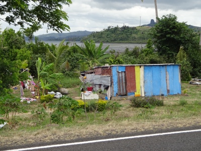
My plan was to cycle anticlockwise once around the entire island (Viti Levu) starting in Nadi. Riding the bike on the country’s main road is not the best way to go. 95% of the road has no shoulder, in most areas there is a lot of traffic on the road and only about every 15th car is at least a little bit considerate of a cyclist on the road. I was glad I haven´t had my second accident there getting hit by a car. Often it was really close. I didn´t feel really safe on the road but I was again able to see / explore many places much more detailed on my bike than you would have seen them from a bus for example. The houses of the locals reminded me of Nicaragua. The simple houses or sheds are build out of wood, plastic and corrugated iron. Some houses have windows, but some don´t. Outside in the yard you mostly see some laundry to dry, which has been washed by hand behind the house or in the river and childrens play with marbles in the dirt. You find a lot of rubbish along the side of the road and in the bushes. The exhaust gases of the cars are often black and incredibly stinky. As soon as you get close to a village, a lot of stray dogs are around. Most of them are females and one thing you recognise is that the teats are loose and some of them almost reach the ground cause they had so many litters. Pretty much all the locals call ‘Bula’, if you pass, which means ‘Hallo’ among other things, and is in this way very nice.

If you´ve cycled through exactly one of those villages 5 minutes ago, where you can see poverty and a very simple way of life, it may be that you suddenly pass a huge wall right next to it. Behind these walls or even far off the main road on the beach you find the mentioned resorts. It seems to be intended that the guests don´t get to see anything outside this paradise. In the resorts local people are employed, which is good, but pretty much all off the places are owned by people from the USA, China, Canada or perhaps Germany, where all the money goes to. The people who spend their holidays there and maybe not even leave the resort at all, probably think that everything is just fine, especially with the local people working there. That’s at least how it seemed to me.
Since I didn´t feel comfortable enough to camp wild, I stayed in hostels along the way. Three nights I spent in two different typical Fijian villages, which was very interesting and where I learned a lot about the culture. In these three days I was impressed and also glad to see that the people living there don´t need a lot to be happy. It is a huge difference to our European standard of living. They cook the meals over a fire place or on a gas stove, they sleep on the floor or in beds, for cooking everything is prepared on the floor where you also have your meals. They eat with the fingers, often drink black tea with lots of sugar and sometimes milk powder and the shower only has cold water. Sometimes it´s not really clean and two nights I had company of cockroaches, a rat and unfortunately also bedbugs. Especially the bedbugs were certainly not my best experience. I don´t exaggerate if I tell you I probably had 100 bites on my entire body.

Compared to all other countries I´ve been to before, among other things, Wifi isn´t really common and rather a special feature. You don´t find it in the library, in cafes or hotels or at least you should´t expect it there. It´s when you realize how often you actually are dependent on the Internet for your trip and for the planning. I´m glad to have lovely parents back home who could take care of the flight I needed to book :) Many of the adults in Fiji have a Smartphone and are on Facebook though.

These are only some impressions and experiences of my time in Fiji …

When you have look at the photos, you will see and maybe understand what I was talking about. Some scenic parts of the island were certainly worth seeing. Photos can document a lot, but they can´t really convey the situation or the feelings and thoughts I had at this moment. Fiji will be a one-time experience for me. I´m delighted to have experienced all that but on the other hand, unfortunately, I´ve also counted the days to departure. I was happy when I finally had the exit stamp in my passport.

BILDER–PICTURES:please click here


Fiji war mein 7. Land auf dieser Reise. Wie die Überschrift schon sagt, habe ich, nachdem ich dort 12 Tage unterwegs war, sehr gemischte Gefühle über das Land.

Jeder oder zumindest viele, die Fiji hören, haben ein ganz bestimmtes Bild im Kopf. Eine Insel im pazifischen Ozean, mit klaren blauem Wasser, weißen Stränden, Pools, schicken Hotels oder Resorts, Strandhäusern, Palmen, Bars und natürlich gutem Wetter. Meine Erfahrungen waren leider oder auch zum Glück etwas anders. Wie und in welcher Art und Weise man ein Land bereist, hat großen Einfluss auf die Eindrücke, die man dort gewinnt. Steigt man am Flughafen aus dem Flugzeug gleich in einen der Reisebusse oder in ein Taxi und wird in eines der teuren Hotels oder Resorts oder auch zu einer anderen Insel gebracht, sieht man zwar auf dem Weg Einiges, aber sobald man dort angekommen ist, sind diese Eindrücke wahrscheinlich auch schon wieder alle vergessen. Leider! Auch diese Leute können zwar jedem erzählen in Fiji gewesen zu sein, aber sie haben von der Kultur und der Lebensweise der Einheimischen nicht wirklich viel mit bekommen. Ich durfte dagegen das „wahre“ Fiji kennenlernen, was mich in vielen Momenten nachdenklich und teils traurig gemacht hat, aber worüber ich gleichzeitig auch irgendwie froh bin.

Mein Plan war es gegen den Uhrzeigersinn von Nadi einmal um die gesamte Insel (Viti Levu) zu fahren. Mit dem Fahrrad auf der einzigen Hauptstraße des Landes unterwegs zu sein ist nicht die optimale Art sich fortzubewegen. Die Straße hat zu 95% keinen Seitenstreifen, es ist in den meisten Bereichen sehr viel Verkehr unterwegs und nur ca. jedes 15te Auto nimmt auch nur annährend Rücksicht auf einen Fahrradfahrer auf der Straße. Ich bin froh, dass ich nicht ein zweites Mal durch ein Auto vom Rad geholt wurde. Viel gefehlt hat oft nicht. Angespannt durch ein unsicheres Gefühl auf der Straße durfte ich durch mein langsames Reisetempo wie immer viele Orte wesentlich detaillierter sehen/ erkunden, als von einem Bus aus. Die Behausungen der Einheimischen haben mich an Nicaragua erinnert, da die einfachen Häuser oder Hütten mit Holz, Plastik und Wellblech zusammengezimmert sind.  Manche Häuser haben Fenster, manche aber auch nicht. Draußen hängt Wäsche zum Trocknen, die mit der Hand hinterm Haus oder im Fluss gewaschen wurde und Kinder spielen mit Murmeln im Dreck. Man sieht viel Müll am Straßenrand und im Gebüsch. Die Abgase der Autos sind oft schwarz und stinken unglaublich. Sobald man in die Nähe eines Dorfes kommt, laufen etliche streunende Hunde herum, wovon die meisten Weibchen sind und die Zitzen ausgeleiert von vielen Würfen bis fast zum Boden reichen. Ziemlich jeder der Einheimischen ruft einem ´Bula´ zu, wenn man vorbei fährt, was unter anderem ´Hallo´ meint und somit sehr nett ist.

Wenn man 5 Minuten zuvor noch durch genau ein solches Dorf gefahren ist, wo man Armut und eine sehr einfache Lebensweise sieht, kann es sein, dass man gleich danach auf einmal an einer hohen Mauer vorbeifährt. Genau hinter einer solchen Mauern oder sogar weit abseits der Straße am Strand befinden sich die erwähnten Resorts. Es scheint beabsichtigt zu sein, dass die Gäste ja nichts außerhalb dieses Paradieses zu Gesicht bekommen. In den Resorts arbeiten zwar Einheimische, was gut ist, aber Eigentümer sind Personen aus den USA, China, Kanada oder vielleicht auch Deutschland, wo das ganze Geld hinfließt. Den Personen, die dort ihren Urlaub verbringen und das Resort vielleicht gar nicht verlassen, wird ein heiles fröhliches Bild, insbesondere durch die dort arbeitenden Einheimischen vorgespielt. So kommt es jedenfalls rüber.

Da ich mich nicht sicher genug gefühlt habe, wild zu zelten, habe ich auf dem Weg in Hostels übernachtet. Drei Nächte habe ich durch glücklichen Zufall in zwei typischen Fiji Dörfern verbracht, was sehr interessant war und wo ich viel über die Kultur gelernt habe. In diesen insgesamt drei Tagen war ich beeindruckt und froh zu sehen, mit wie wenig die Menschen dort glücklich zu sein scheinen. Es ist ein riesen Unterschied zu unserem europäischen Lebensstandard. Gekocht wird über einer Feuerstelle oder mit Gas, geschlafen auf dem Fußboden oder im Bett, zum Kochen wird alles auf dem Boden vorbereitet, wo ebenfalls gegessen wird. Gegessen wird mit den Fingern, oft wird schwarzer Tee mit viel Zucker und manchmal Milchpulver getrunken und die Dusche hat nur kaltes Wasser. Die Sauberkeit lässt manchmal zu wünschen übrig und nachts hatte ich zwei Nächte Gesellschaft von Kakerlaken, einer Ratte und leider auch Bettwanzen. Gerade die Bettwanzen waren sicherlich nicht dir beste Erfahrung. 100 Bisse am gesamten Körper ist wohl keine Übertreibung.

Auffällig im Gegensatz zu allen anderen Ländern zuvor ist unter anderem auch, dass in Fiji Wifi eine ziemlich Besonderheit ist. Es ist weder in der Bücherei, in Cafés oder Hotels zu finden/ eine Selbstverständlichkeit. Erst dann merkt man, wie sehr man manchmal beim Reisen und bei der Planung auf das Internet angewiesen ist. Da ist man froh, dass die Eltern zuhause mal die Flugbuchung für einen übernehmen können:) Viele der Erwachsenen in Fiji haben jedoch ein Smartphone und Facebook.

Es sind nur einige Eindrücke meiner Zeit in Fiji…

Wenn ihr die Fotos anguckt, werdet ihr sehen und vielleicht verstehen, was ich meine. Landschaftlich waren einige Teile der Insel sicherlich sehenswert. Fotos können zwar vieles dokumentieren, aber die Situation oder die Gefühle und Gedanken, die ich in diesem Moment hatte, nicht wiedergeben. Fiji wird für mich ein einmaliges Erlebnis bleiben, worüber ich einerseits froh bin, es erlebt zu haben aber andererseits auch leider die Tage gezählt habe und mich gefreut habe, als ich endlich meinen Ausreisestempel in meinem Reisepass hatte.

BILDER–PICTURES: please click here

Last day, last hike… bye Hawaii!

I arrived to Honolulu late in the evening and was glad to finally get to Josh’s place (my second home during my time in Hawaii). After such an exciting day I had earned my sleep, which I had little of the night before. For Wednesday, my last day in Hawaii, I had planned a final hike. I wanted to hike the Moanalua Middle Ridge Trail, which leads to the end of the Haiku Stairs, also known as the Stairway to Heaven. Even though I was knackered from Tuesday, I wanted to make the most of the day so I made my way to the Moanalua Valley in the morning. The hike was challenging but fun. Unfortunately, I had to turn around just before I reached my goal. The weather wasn’t great from the start and only worsened during the day – I had to fight rain, a steep slippery path, strong wind and very low visibility. My head told me that I should turn around, so I did… even though I was very close. I was quite annoyed, but it was safer and I wouldn’t have seen much from the top anyway. The evening was pretty relaxed – eating Taco Bell, watching television and lying on the floor. The next day I packed again and in the evening Josh brought me to the airport. I am very happy that I´ve finally visited Hawaii, which I had wanted to explore for so long. Thanks to all the people who made my time there just so awesome and unique!

BILDER- PICTURES: please click here


Ich war abends erst realtiv spät in Honolulu angekommen und froh, als ich endlich in Josh´s Wohnung (während meiner Zeit in Hawaii eigentlich schon mein zweites Zuhause) angekommen war. Meinen Schlaf, der die Nacht zuvor deutlich zu kurz gekommen war, hatte ich mir nach einem so aufregenden Tag deutlich verdient. Für Mittwoch, was auch mein letzter Tag in Hawaii sein sollte, hatte ich eine letzte Wanderung geplant. Ich wollte den Moanalua Middle Ridge Trail wandern, der auf legale Weise zum Ende der Haiku Stairs oder auch bekannt als Stairway to Heaven führt. Super geschafft von Dienstag, wollte ich den Tag dennoch nutzten und so habe ich mich morgens auf den Weg zum Moanalua Valley gemacht. Die Wanderung war anspruchsvoll aber hat Spaß gemacht. Leider musste ich kurz vor meinem Ziel umdrehen. Das Wetter war von Vornherein nicht perfekt und hatte sich im Laufe des Tages nur noch verschlechtert, sodass ich weiter oben mit Regen, einem rutschigen steilen Pfad, starkem Wind und sehr geringer Sicht kämpfen musste. Meine Vernunft hat mir gesagt, dass ich umdrehen sollte, was ich auch gemacht habe… auch wenn ich so nah dran war. Es hat mich ziemlich geärgert, aber es war sicherer und viel gesehen hätte ich von ganz Oben sowieso nicht. Abends war ich erst recht geschafft, sodass Essen von Taco Bell, Fernsehen und auf dem Boden rumliegen angesagt war. Den nächsten Tag habe ich mal wieder gepackt und abends ging es zum Flughafen. Ich bin sehr froh, dass ich endlich das Land (Staat) besucht habe, was ich schon so lange erkunden wollte. Danke an alle Leute, die meine Zeit dort einfach so genial und einzigartig gemacht haben.

BILDER- PICTURES: please click here

A big variety of landscapes, adventurous company, interesting hikes and a good time!

After having a great time travelling on Oahu and Kauai, it was time for my third island. I was planning to fly to the Big Island and I had been wondering for a long time whether I should take my bike with my to cycle around the Island or not. Because of the relatively large effort for only one week cycling, I decided to not bring the bike. In hindsight I am glad about it. If you are more interested in aimlessly exploring an Island than in just making a good milage on the main road, the bike is kind of a ballast. After a one-day stopover in Honolulu, I flew one more time with only my handluggage and without my constant companion to Kona. On Big Island, my first stop was the small town of Hawi, where I was very warmly welcomed by my couchsurfing host Tim. Hawi is located in the north of the Island and since Tim had two days off, it was time for ´game, fun and excitement´. After a good breakfast on Tuesday we went to `Pololu Valley’, where we hiked into the third valley. A clear trail somehow ended at one point so we had to find a way through the jungle of bushes and branches. It was a lot of fun. In the meantime we jumped in the river and enjoyed the cold water and according to the motto ´once muddy and sweaty .. now it dosn´t matter anymore´ we were definitely dirty enough for a shower back home. The reward was a cold beer, a delicious pizza and a game night with a couple of friends :)
Wednesday and Thursday we did two more hikes, we went to the beach and had the best ‘Shave Ice Special’ ever. There were brilliant, adventurous and funny days with Tim and a reunion was already planned.
On Thursday I went to Hilo, where I met my next Couchsurfing host Maurice. On Friday I visited the ‘Rainbow Falls’ with nice and refreshing water and did a small bike tour. Since Maurice has moved to the island only 5 months ago and didn´t have much time to explore yet, we planned a road trip for Saturday. We drove up Mauna Kea, with 4207m (13.802ft) the highest mountain in Hawaii and it´s also regarded as the highest mountain in the world (if you include the part underwater). For me, the height was special and a first even without the part under water. In the afternoon we walked the Puna Trail, but we didn´t quite manage to get back with clean shoes or before dark. I was glad Maurice brought some flashlights.
Sunday I went on to my 3rd Couchsurfinghost, Cynthia near Kalapana on Big Island. After a walk to a black sand beach and visiting the Lava Tree State Park that same day, I headed to Pahala on Monday to visit the Ka’u Coffee Plantation. On the way back I met Tim (CS host in Hawi) in Volcano, where we went to the Kilauea Iki Crater in the afternoon. After the hike we went back to Cynthia where Tim could also stay over nigth. Our plan and the reason why Tim came all the way to the south of the island was the hot lava, which is currently flowing into the ocean. We wanted to hike to that spot in the dark and watch the sunrise. As planned on Tuesday, at about 3:30 am, in the middle of the night.. still dark, we walked to the point where the lava hits the ocean.

A natural spectacle which, despite the heavy rain in the morning, was definitely worth it. After the sun had risen we saw more smoke than red lava, so that we made our way back. After a good breakfast, Tim and I went on towards Kona, since my flight would leave from there back to Honolulu in the evening. Our first stop was at ‘South Point’ (southernmost point of the USA), where we couldn´t miss out on the South Point Cliff Dive with such a calm and clear ocean. The second stop was the Papakolea Greensand Beach, where the hike felt like it would take forever, probably caused by the tiredness which got worse during the day. Happy and very enthusiastic about my time on the Big Island, I got dropped off by Tim at the Kona airport from where I flew back to Honolulu. What a long and exciting day.

BILDER- PICTURES: please click here


Nachdem ich Oahu und Kauai unsicher gemacht hatte, wurde es nun Zeit für meine dritte Insel. Big Island stand auf dem Plan und ich hatte lange hin und her überlegt, ob ich mein Fahrrad mit zu dieser Insel nehme, um einmal herum zu fahren oder nicht. Auf Grund des relativ großen Aufwands für nur eine Woche Radfahren, habe ich mich dagegen entschieden. Im Nachhinein bin ich froh darüber. Wenn man ziellos eine Insel erkunden und nicht nur auf der Hauptstraße seine Kilometer machen will, ist das Fahrrad dann doch ein Ballast. Nach einen eintägigen Zwischenstopp in Honolulu bin ich also ein weiteres Mal mit leichtem Gepäck und ohne meinen ständigen Wegbegleiter nach Kona geflogen. Auf Big Island war mein erster Stop der kleine Ort Hawi, wo ich sehr herzlich von meinem Couchsurfing host Tim empfangen wurde. Hawi liegt ganz im Norden der Insel und da Tim zwei Tage frei hatte, standen Spiel, Spaß und Spannung auf dem Plan. Am Dienstag sind wir nach einem guten Frühstück zum `PololuValley´ aufgebrochen, wo wir bis ins dritte Tal gewandert sind. Ein Trail war irgendwann nur noch teilweise vorhanden, sodass wir uns einen Weg durch den Dschungel von Büschen und Ästen bahnen mussten. Es war ein riesen Spaß. Zwischendurch wurde sich kurz im Bach erfrischt und ganz nach dem Motto ´einmal matschig und verschwitzt…dann ist jetzt auch egal´ sind wir irgendwann wieder dreckig genug für eine Dusche zurück gewesen. Die Belohnung war ein kaltes Bier, eine leckere Pizza und ein Spieleabend mit ein paar Freunden:)
Mittwoch und Donnerstag folgten noch zwei weitere Wanderungen, ein Strandbesuch und das beste ´Shave Ice Special´ überhaupt. Es waren geniale, abenteuerreiche und lustige Tage mit Tim und ein Wiedersehen wurde schon geplant.
Donnerstag ging es für mich weiter nach Hilo, wo ich meinen nächsten Couchsurfing host Maurice kennen gelernt habe. Am Freitag habe ich mir dort die Zeit mit einem Besuch der ´Rainbow Falls´ und einer kleinen Radtour vertrieben. Da Maurice erst vor 5 Monaten auf die Insel gezogen ist und noch nicht viel Zeit zum Erkunden hatte, haben wir für Samstag einen Road-Trip geplant. Es ging auf Mauna Kea, mit 4207m (13.802ft) der höchste Berg Hawaiis, der aber auch als höchster Berg der Welt angesehen wird(wenn man den Teil Unterwasser mitrechnet). Für mich war die Höhe selbst ohne den Teil unter Wasser eine Primiere. Nachmittags sind wir noch den Puna Trail gewandert, wobei wir es nicht ganz geschafft haben mit sauberen Schuhen vor Einbruch der Dunkelheit zurück zu sein.
Sonntag ging es zu meinem 3. Couchsurfinghost, Cynthia in der Nähe von Kalapana auf Big Island. Nach einem Spaziergang zu einem schwarzen Sandstrand und dem Besuch des Lava Tree Stateparks am selben Tag, bin ich am Montag nach Pahala getrampt, um dort die Ka´u Kaffeeplantage zu besichtigen. Auf dem Rückweg habe ich mich mit Tim (CS host von Hawi) in Volcano getroffen, wo wir nachmittags noch in den Kilauea Iki Crater gewandert und danach zusammen zurück zu Cynthia gefahren sind, wo Tim ebenfalls übernachten konnte. Plan und Grund dafür, dass Tim in den Süden der Insel gekommen ist, war die momentan in das Meer fließende heiße Lava, zu der wir wandern wollten. Gesagt, getan sind wir Dienstag gegen 3:30 Uhr, mitten in der Nacht, im Dunkeln zu dem Punkt gewandert, wo die Lava auf den Ozean trifft. Ein Naturschauspiel, das trotz des anfangs starken Regens jeden cm der nassen Kleidung Wert war. Nachdem die Sonne aufgegangen war und man nun mehr Rauch als rote Lava sah, haben wir uns auf den Rückweg gemacht. Gestärkt mit ein guten Frühstück sind Tim und ich in Richtung Kona aufgebrochen, da von dort aus spät abends mein Flug zurück nach Honolulu ging. Erster Zwischenstopp war beim ´South Point´(südlichster Punkt der USA), wo wir uns den South Point Cliff Dive bei so ruhigem und klarem Meer nicht entgehen lassen konnten. Zweiter Stop war der Papakolea Green Sand Beach, zu dem die Wanderung auf Grund der eintretende Müdigkeit eine gefühlte Ewigkeit gedauert hat. Glücklich und sehr begeistert von meiner Zeit auf dem Big Island, wurde ich abends von Tim in Kona am Flughafen abgesetzt und es ging zurück nach Honolulu. Was für ein langer und aufregender Tag.

BILDER- PICTURES: please click here

Endorphins on Kauai- what a beautiful Island

Kauai, I finally arrived in Hawaii :) Already at the landing approach it was great to see that there was not a single skyscraper and everything was so nice and green:) After my Couchsurfing Host John had picked me up at the airport, I learned why you don´t find any high buildings on the Island: On Kauai, according to the law, houses are not allowed to be build higher than the height of a palm tree. On the whole island there is only one house, which is higher, as it was constructed before this law passed.

Since I had landed relatively early, we still had plenty of time and did a little ‘bike trip’ with the motorbike. We brought snorkel gear and went to Princeville in the north-eastern part of the island. The further we drove and the more I saw from the island, the more I got confirmed in my decision to explore this Island as well. Just single-lane roads, not too much traffic, green hills, beautiful coastal scenery, cute places and it just felt like I could fly sitting on the back of the motorcycle. On my first day we already had visited some beautiful places; a botanic garden, a lighthouse, a hidden beach, the ´Queens Bath´ and I was snorkeling for the first time.. how exciting. The water is so incredibly clear.

The next day, John made me a ‘lei’ with flowers from his own garden. It´s the flower necklace which many associate with Hawaii. It wil be given to other persons as a gift for quite a variety of occasions and reasons. The occasion may be graduation, a wedding, congratulations, health, birth or death, love, friendship or to welcome someone. But you can wear it without a reason as well. If it´s given to you on a festive or special occasion, someone usually does it in a special way. There are also quite a few different ´leis´. For the most part they are made out of flowers, although the type of flower can vary. But they can also be made from leaves, mussels or feathers.
After John had handed me my first ‘lei’, we went for a bikeride with two of John’s special bicycles. We went along the coast on a nice bike path and it was fun to drive with one of these more special bikes. How John managed to not fall off his bike is a mystery to me though(see video). I tried to ride his bike, but I failed miserably. In the afternoon after being a couple of hours out of the sun we visited the local Farmes Market and a hiked to the top of the ´Sleeping Giant´. And I was still excited about the Island.

On Thursday we drove up to the northern part of the Island again, where we hiked one part of the Kalalau Trail and further on to the Hanapapi’ai Falls. Unbelievable, breathtaking, beautiful and unreal are words that describe the landscape and the whole day pretty well. If you see the photos, you may get an idea what I´m talking about.
Friday I headed towards Waimea Canyon on my own where I did three different hikes, which were all quite incredible. The highlight for me was the Pu’u O Kila Trail and the Kalepa Ridge Trail from where you could see the Kalalau Valley and some of the famous Napali Coast. This part of the coast I had seen before on so many photos and now finally I was able to go there. It was breathtaking.
The last day on Kauai I once again was able to get to experience something totally new and unique for me. We were snorkeling the second time and suddenly there were not only the colorful fish but also a turtle very close to us in the water. That was definitely a highlight of my small trip to this beautiful Island Kauai.

BILDER- PICTURES: please click here


Kauai, endlich in Hawaii angekommen:) Schon beim Landeanflug habe ich erleichtert festgestellt, dass kein einziges Hochhaus zu sehen war und alles einfach so schön grün war:) Nachdem mich mein Couchsurfing Host John vom Flughafen abgeholt hatte, habe ich auch erfahren wieso: Auf Kauai darf nach dem Gesetzt kein Haus die Höhe einer Palme überschreiten. Auf der gesamten Insel gibt es nur ein Haus, das gegen das Gesetz verstößt, da es um Zeitpunkt des Bau´s diese Regel noch nicht gab.

Da ich relativ früh gelandet war und der Tag noch lang war, haben wir noch einen kleinen ´Road- Trip´ mit dem Motorrad gemacht. Schnorchel Ausrüstung im Gepäck ging es Richtung Princeville im nord-östlichen Teil der Insel. Je weiter wir fuhren und je mehr ich von der Insel sah, desto mehr wurde ich in meiner Entscheidung bestätigt einen Ausflug unternommen zu haben, um auch diese Insel zu erkunden. Nur einspurige Straßen, nicht zu viel Verkehr, grüne Hügel, wunderschöne Küstenlandschaft, niedliche Orte und das Gefühl zu fliegen, als ich so hinten auf dem Motorrad saß. Schon an meinem ersten Tag hatten wir einige wunderschöne Orte besucht; einen paradiesischen Garten, einen Leuchtturm, einen versteckten Strand, das Queens Bath und ich war das aller erste Mal Schnorcheln.. wie aufregend. Das Wasser ist so unglaublich klar.

Am nächsten Tag hat mir John morgens ein ´Lei´  mit Blumen aus dem eigenen Garten gefertigt. Ins Deutsche übersetzt ist es die Blumenkette, die viele mit Hawaii in Verbindung bringen. Es wird aus ganz unterschiedlichen Anlässen und Gründen an andere Personen als Geschenk übergeben. Anlass kann der Schulabschluss sein, eine Hochzeit, Glückwünsche, Gesundheit, Geburt oder Tod, Liebe, Freundschaft oder Willkommen heißen. Man kann es allerdings auch genauso gut einfach so tragen. Wenn man es bei einem festlichen oder bestimmten Anlass bekommt, wird es meistens auf spezielle Art übergeben. Es gibt ebenfalls ganz verschiedene Ketten. Größtenteils werden sie aus Blumen hergestellt, wobei die Art der Blume variieren kann. Genauso gut können sie aber auch aus Blättern, Muscheln oder Federn hergestellt sein.
Nachdem ich also meine erste ´Lei´ überreicht bekommen hatte, sind wir mit zwei von Johns Rädern zu einer Fahrradtour aufgebrochen. Wir sind entlang der Küste auf einem schönen Radweg unterwegs gewesen und es war sehr amüsant mal mit einem anderen etwas spezielleren Fahrrad zu fahren. Wie John es allerdings geschafft hat nicht vom Rad zu fallen ist mir ein Rätsel (siehe Video). Ich habe versucht darauf zu fahren, bin allerdings kläglich daran gescheitert. Am Nachmittag nach einer Sonnenpause folgte noch ein Besuch des örtlichen Farmes Market und eine Wanderung auf den ´Sleeping Giant´. Und weiterhin war ich begeistert von der Insel.

Donnerstag sind wir nochmals mit dem Motorrad zum nördlichen Teil der Insel gefahren, wo wir einen Teil des Kalalau Trails und weiter zu den Hanapapi´ai falls gewandert sind. Unglaublich, atemberaubend, wunderschön und unwirklich sind Worte, die die Landschaft und den gesamten Tag sehr gut beschreiben. Wenn ihr die Fotos seht, könnt ihr es vielleicht nachvollziehen.
Freitag bin ich dann alleine aufgebrochen und Richtung Waimea Canyon getrampt. Dort habe ich drei verschiedene Wanderungen gemacht, die alle ziemlich unglaublich waren. Highlight für mich war allerdings der Pu´u O Kila Trail und der Kalepa Ridge Trail, von denen aus man in das Kalalau Tal sehen und einen Teil der so bekannten Napali Coast bestaunen konnte. Diesen Teil der Küste hatte ich vorher auf schon so vielen Fotos gesehen und nun endlich war ich da. Es war atemberaubend.
Den letzten Tag auf Kauai durfte ich noch mal etwas für mich ganz neues und einzigartiges erfahren. Wir waren ein zweites Mal schnorcheln und plötzlich waren da nicht nur die bunten Fische sondern auch eine Schildkröte ganz in der Nähe von uns im Wasser. Was für ein krönender Abschluss für meinen kleinen Ausflug zu dieser traumhaften Insel Kauai.

BILDER- PICTURES: please click here

Oahu- skyscraper in Honolulu and some nature around it

Hawaii. For about 5 years it has been one of the places that I have really wanted to visit. My desire to explore Hawaii had been driven by getting reports from friends who had already travelled there and of course looking at photos. I remember that when I was staying with Cathy, while wwoofing in Vernon in 2011, she showed me her vacation photos of Hawaii. A dream! I have to go there, and if I´m traveling around the world anyway it´s kind of on my way. When I talk about Hawaii, I mean all the islands together, even though some people only think of Big Island.
I arrived at Oahu in Honolulu on Wednesday and was picked up at the airport by my Couchsurfing host Josh. It makes the journey from the airport much easier as it can be a struggle to transport two heavy pieces of luggage. So I was super happy and grateful, and at the same time quite tired from having to get up so early, the flight and the 5 hours time difference. The day after I arrived, Josh and I took a road trip. The day started with the sunrise and a Hawaiian breakfast (rice, egg, Portuguese sausage and spam). In the afternoon, after a few other things, we did a tour around Oahu which ended with the sunset on the other side of the island. We made a few stops and I was relieved to find out that the entire island is not as developed as the area around Honolulu. I was a little disappointed with the extent of the development around Honolulu, but it shows again that I did not spend much time planning my visit. It was terrifying how packed with builings (normal buildings, as well as skyscrapers) this side of the island is. When I think of Hawaii (and many others think this same way), I think of a green island with empty white beaches, palm trees, the specially shaped mountains, beautiful coastal areas and of course Hawaiian shirts and leis.
On Friday, to get a better impression of Honolulu and Waikiki Beach, I explored the area on foot. At the end of the day I had walked 17km and seen many full beaches, lots of traffic, loads of tourists (mostly Japanese) and well-visited shopping centers. Some tourists spend their entire holiday in this area of the island, which for me it is completely incomprehensible.

On Saturday I took two small hikes. In the morning I hiked the Koko Crater Trail and then afterwards the Diamond Head Trail. Both walks headed uphill and gave you a great view :), which also showed me more of the southwestern side of the mountains and how gigantic Honolulu is. Sunday and Monday were relatively relaxed. I finally translated some blog entries, Josh and I went to a beach on the other side of the island and I went to the National Memorial Cemetery of the Pacific from where you had a good view of Honolulu again.

My bike was still packed, because I wasn´t sure if I would go to another island. If I can save myself from the unpacking and packing and the assembly and disassembly, especially for such a short period of time, I will. And so on Tuesday I did travel on with only my hand luggage. How nice it is to only have to worry about a small backback at the airport. Off to Kauai!!!:)

BILDER-PICTURES: please click here


Hawaii. Seit ca. 5 Jahren ist es eines der Orte, die ich auf jeden Fall besuchen will. Ausschlaggeben für den Wunsch Hawaii eines Tages zu erkunden waren unter anderem natürlich Fotos aber auch Berichte von ein paar Freunden, die schon dort gewesen sind. Ich kann mich erinnern, dass ich 2011 bei Cathy (in Vernon) zum wwoofen war und sie mir ihre Urlaubsfotos von Hawaii gezeigt hat. Ein Traum! Da muss man einfach mal hin und wenn man schon um die Welt reist, liegt es ja sozusagen auf dem Weg. Wenn ich über Hawaii spreche, meine ich alle Inseln zusammen, auch wenn einige damit nur Big Island assoziieren.

Ich bin also am Mittwoch in Honolulu auf Oahu angekommen und wurde von meinem Couchsurfinghost Josh am Flughafen eingesammelt. Es vereinfacht die Weiterreise vom Flughafen immer sehr, da es wirklich ein Akt ist die beiden schweren Gepäckstücke zu transportieren. Ich war also super froh und dankbar und gleichzeitig auch ziemlich fertig von dem frühen Aufstehen, dem Flug und den 5 Stunden Zeitunterschied. Den Tag nach meiner Ankunft haben Josh und ich einen Road Trip gemacht. Der Tag wurde mit Sonnenaufgang gucken gestartet und wir hatten ein hawaiisches Frühstück (Reis, Ei, Portugiesische Würstchen und Spam). Nach dem Mittag und ein paar Erledigungen haben wir eine Tour um die Insel gemacht, die mit Sonnenuntergang gucken auf der anderen Seite der Insel endete. Wir haben zwischendurch ein paar Stops gemacht und ich durfte mit Erleichterung feststellen, dass nicht die ganze Insel so zugebaut ist, wie die Gegend um Honolulu. Was das angeht war ich doch ein wenig enttäuscht, aber es zeigt auch mal wieder, dass ich nicht ganz so viel Zeit in die Planung investiert habe. Es war erschreckend, wie zugebaut (normale, wie auch Hochhäuser) diese Seite der Insel ist. Wenn ich an Hawaii denke und ich würde sagen, es geht vielen so, dann denke ich an eine grüne Insel mit weißen leeren Ständen, Palmen, den besonders geformten Bergen, schönen Küstenabschnitten und .. natürlich Hawaiiketten und Shirts;)

Um einen besseren Eindruck von der Gegend Downtown Honolulu und Waikiki Beach zu bekommen, bin ich Freitag auf Erkundungstour gegangen, ausnahmsweise zu Fuß. Am Ende des Tages hatte ich gut 17km auf dem Tacho und auch genug von vollen Stränden, viel Verkehr, vielen Touristen (erstaunlicher Weise größtenteils Japaner) und gut besuchten Einkaufszentren gesehen. Manche Touristen verbringen ihren ganzen Urlaub in diesem Bereich der Insel, für mich ja völlig unverständlich.
Samstag war es Zeit für zwei kleine Wanderungen. Morgens bin ich den Koko Krater Trail und danach noch den Diamond Head Trail gewandert. Beide Wanderungen gingen bergauf und man hatte eine großartige Aussicht:) , die allerdings noch mehr gezeigt hat, wie bebaut die südwestliche Seite der Berge und wie riesig Honolulu ist.
Sonntag und Montag waren relativ entspannt. Ich habe endlich die Blogeinträge übersetzt, wir sind zu einem Strand auf der anderen Seite der Insel gefahren und ich bin zum National Memorial Cemetery of the Pacific gegangen, von wo aus man nochmal eine gute Sicht auf Honolulu hatte.

Mein Fahrrad blieb derweil eingepackt, da ich mir noch nicht sicher war, ob ich nicht doch noch eine andere Insel besuche. Wenn ich mir das Ein- und Auspacken und das Zusammen- und Auseinanderbauen sparen kann, besonders für einen so kurzen Zeitraum, sage ich nicht nein. Dienstag ging es dann tatsächlich weiter und zwar nur mit Handgepäck. Wie schön es doch ist, sich am Flughafen nur um einen kleinen Rucksack kümmern zu müssen. Auf nach Kauai!!:)

BILDER-PICTURES: please click here